world.wikisort.org - Royaume-Uni
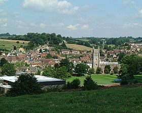
Bruton est une petite ville anglaise du Somerset. Située vers 19 km sud-ouest de Frome, Bruton est identifiée dans le Domesday Book de 1086 comme Briuuetone. Le nom vient de la rivière Brue, qui traverse la ville de l'est en ouest de sa source à Brewham. La ville a une population de 2 907 habitants en 2014, et une communauté focalisée sur la rue principale.
| Bruton | |
 Vue de Bruton (2005) | |
| Administration | |
|---|---|
| Pays | |
| Nation | |
| Comté | Somerset |
| District | South Somerset |
| Force de police | Avon and Somerset |
| Incendie | Devon and Somerset |
| Ambulance | South Western |
| Code postal | BA10 |
| Démographie | |
| Population | 2 907 hab. (2014) |
| Géographie | |
| Coordonnées | 51° 06′ 48″ nord, 2° 27′ 10″ ouest |
| Localisation | |
| Liens | |
| Site web | http://www.brutontown.com/ |
| modifier |
|
Géographie
Située dans une combe, la ville a été soumise aux inondations, particulièrement en 1917. Récemment, une digue était modifiée pour faire face à des crues centennales.
Transport
La ville a une gare avec des services habituels à Yeovil, Weymouth et Bath.
Éducation
Il y a trois collèges dans la ville : Sexey's School (en) qui est un collège d'état, Bruton School for Girls, et King's School, mais aussi une école primaire et une école Steiner-Waldorf.
Commerce
Dans la rue principale, il y a quelques restaurants qui proposent des cuisines chinoises aussi bien que biologiques. Il existe aussi, trois pubs : The Castle, The Sun, et The Blue Ball.
Liens externes
- Portail de l’Angleterre
На других языках
[en] Bruton
Bruton (/ˈbruːtən/ BROO-tən) is a market town, electoral ward, and civil parish in Somerset, England, on the River Brue and the A359 between Frome and Yeovil. It is 7 miles (11 km) south-east of Shepton Mallet, just south of Snakelake Hill and Coombe Hill, 10 miles (16 km) north-west of Gillingham and 12 miles (19 km) south-west of Frome in South Somerset district. The town and ward have a population of 2,907.[1] The parish includes the hamlets of Wyke Champflower and Redlynch. Bruton has a museum of items from the Jurassic era onwards.- [fr] Bruton (Somerset)
Другой контент может иметь иную лицензию. Перед использованием материалов сайта WikiSort.org внимательно изучите правила лицензирования конкретных элементов наполнения сайта.
WikiSort.org - проект по пересортировке и дополнению контента Википедии

