world.wikisort.org - United_Kingdom
Woodmansey is a village and civil parish in the East Riding of Yorkshire, England. It is situated approximately 1.5 miles (2.4 km) south-east of Beverley on the A1174 road from Hull to Beverley.
| Woodmansey | |
|---|---|
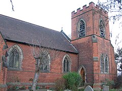
 St Peter's Church, Woodmansey | |
 Woodmansey Location within the East Riding of Yorkshire | |
| Population | 7,109 (2011 census)[1] |
| OS grid reference | TA055379 |
| Civil parish |
|
| Unitary authority |
|
| Ceremonial county |
|
| Region |
|
| Country | England |
| Sovereign state | United Kingdom |
| Post town | BEVERLEY |
| Postcode district | HU17 |
| Dialling code | 01482 |
| Police | Humberside |
| Fire | Humberside |
| Ambulance | Yorkshire |
| UK Parliament |
|
Geography

The civil parish of Woodmansey consists of the villages of Woodmansey and Dunswell and the hamlet of Thearne. According to the 2011 United Kingdom census, Woodmansey parish had a population of 7,109,[1] an increase on the 2001 UK census figure of 6,497.[3]
The village has a small primary school, Woodmansey Church of England Voluntary Controlled Primary School, which was opened in 1856 and celebrated its 150th anniversary in 2006.[4][5]
Opposite the school is the village church of St Peter's which was built to a design by Alfred Beaumont and opened in 1898.[6]
The Warton Arms (pictured) with its thatched roof, is the only pub in the village.[7]
Governance
The civil parish was in the Beverley and Holderness parliamentary constituency until the 2010 general election when it was transferred to the constituency of Haltemprice and Howden.[2]
References
- UK Census (2011). "Local Area Report – Woodmansey Parish (1170211292)". Nomis. Office for National Statistics. Retrieved 28 February 2018.
- "Are you ready to vote in the next election?". East Riding News. East Riding of Yorkshire Council. April 2010. p. 3.
- UK Census (2001). "Local Area Report – Woodmansey Parish (00FB163)". Nomis. Office for National Statistics. Retrieved 24 February 2020.
- "Woodmansey Church of England Voluntary Controlled Primary School". Department for Education. Retrieved 1 November 2016.
- Baggs, A. P.; Brown, L. M.; Forster, G. C. F.; Hall, I.; Horrox, R. E.; Kent, G. H. R.; Neave, D. (1989). "'Outlying townships: Thearne and Woodmansey'". In Allison, K. J. (ed.). A History of the County of York East Riding: Volume 6, the Borough and Liberties of Beverley. British History Online. London: Victoria County History. pp. 295–301. Retrieved 31 October 2016.
- "St Peter's Woodmansey". Beverley Minster. Retrieved 27 January 2012.
- "Warton Arms". CAMRA Hull & East Yorkshire Branch. Retrieved 31 October 2016.
- Gazetteer — A–Z of Towns Villages and Hamlets. East Riding of Yorkshire Council. 2006. p. 12.
| Wikimedia Commons has media related to Woodmansey. |
Другой контент может иметь иную лицензию. Перед использованием материалов сайта WikiSort.org внимательно изучите правила лицензирования конкретных элементов наполнения сайта.
WikiSort.org - проект по пересортировке и дополнению контента Википедии