world.wikisort.org - United_Kingdom
Manton is a village in the county of Rutland in the East Midlands of England. It lies south-west of Rutland Water. The population of the civil parish at the 2001 census was 364, and after including Gunthorpe decreased slightly to 359 at the 2011 census.[3]

| Manton | |
|---|---|
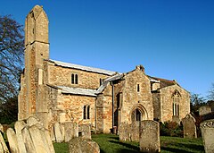
 St Mary's Church, Manton | |
 Manton Location within Rutland | |
| Area | 1.85 sq mi (4.8 km2) [1] |
| Population | 364 2001 Census[2] |
| • Density | 197/sq mi (76/km2) |
| OS grid reference | SK880045 |
| • London | 82 miles (132 km) SSE |
| Unitary authority |
|
| Shire county |
|
| Ceremonial county |
|
| Region |
|
| Country | England |
| Sovereign state | United Kingdom |
| Post town | OAKHAM |
| Postcode district | LE15 |
| Dialling code | 01572 |
| Police | Leicestershire |
| Fire | Leicestershire |
| Ambulance | East Midlands |
| UK Parliament |
|
History
The name of the village probably means "farm/settlement of Manna" or "communal farm/settlement".[4]
Manton does not appear in the 1086 Domesday Book, but may have been one of seven outlying estates of the king's manor of "Hameldune Cherchesoch". One of the early mentions of Manton Manor dates from the reign of Henry I (1100–1135). It remained a dominant feature of the village until the early 20th century, although it changed hands many times between the Abbots of Cluny, the Kings of England and those they rewarded.
Manton stands on high ground with good water wells that remain in St Mary's Road and Priory Road. A main route between London and Yorkshire passed through in the 16th century. The main occupations were pasturing of sheep, cattle and horses, and farming of grass, wheat and other crops.
Its central point remains a small village green with lime trees planted to mark the coronation of King George V in 1911. Many larger stone houses and slate-roofed cottages still stand amid the later buildings. The public services that remain include a church, a pub, a village hall, a residential home and an antique shop.[5] The environment changed radically with the emergence of Rutland Water in the 1970s.
Transport
Manton is served by an hourly daytime bus service, Monday to Friday, between Oakham and Corby.[6]
The village had a railway station, Manton Junction, situated to the south of the village. It closed in the 1960s and the station buildings are now used as a factory. The line remains and passes underneath the village through a tunnel.
Attractions
Manton has a number of attractions, including the newly refurbished Horse and Jockey. This is the only pub on the cycle route around Rutland Water.
Regular social events are held, including book club meetings and safari suppers.
The village's outdoor Chater Close playground and skate ramps are popular with children.[7][8]
References
- "A vision of Britain through time". University of Portsmouth. Retrieved 18 March 2009.
- "Rutland Civil Parish Populations" (PDF). Rutland County Council. 2001. Archived from the original (PDF) on 12 October 2007. Retrieved 15 March 2009.
- "Civil Parish population 2011". Neighbourhood Statistics. Office for National Statistics. Retrieved 25 June 2016.
- "Key to English Place-names".
- Parish Council site.
- Timetable.
- "Manton Playgrounds". Manton Parish Council. 23 February 2016. Retrieved 2 April 2018.
- "Manton Skate Ramps". The Skateparks Project. 26 March 2015. Retrieved 2 April 2018.
External links
![]() Media related to Manton, Rutland at Wikimedia Commons
Media related to Manton, Rutland at Wikimedia Commons
Другой контент может иметь иную лицензию. Перед использованием материалов сайта WikiSort.org внимательно изучите правила лицензирования конкретных элементов наполнения сайта.
WikiSort.org - проект по пересортировке и дополнению контента Википедии