world.wikisort.org - United_Kingdom
Lower Falls was one of the nine district electoral areas which existed in Belfast, Northern Ireland from 1985 to 2014. Located in the west of the city, the district elected five members to Belfast City Council and contained the wards of Beechmount; Clonard; Falls; Upper Springfield; and Whiterock. Lower Falls formed part of the Belfast West constituencies for the Northern Ireland Assembly and UK Parliament. The district, along with the neighbouring Upper Falls district took its name from the Falls Road, one of the main arterial routes in the west of the city.
| Lower Falls District Electoral Area | |
|---|---|
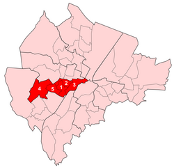 Map showing Lower Falls wards within Belfast | |
| Population | (2008 Estimate) |
| District |
|
| County |
|
| Country | Northern Ireland |
| Sovereign state | United Kingdom |
| UK Parliament |
|
| NI Assembly |
|
History
Lower Falls was created for the 1985 local elections. The Falls and Clonard wards had previously been in Area F, with the remaining wards part of Area D. It was abolished for the 2014 local elections. The Falls and Clonard wards joined the Court District Electoral Area, while the remaining wards became part of a new Black Mountain District Electoral Area.
Wards
| Map | Ward | Population (2011 Census) | Catholic | Protestant | Other | No Religion | Area | Density | NI Assembly | UK Parliament | Ref |
|---|---|---|---|---|---|---|---|---|---|---|---|
| 1 | Beechmount | 5,485 | 90.8% | 6.1% | 0.6% | 2.5% | 0.84 km2 | 6,530/km2 | Belfast West | Belfast West | [1] |
| 2 | Clonard | 4,975 | 90.5% | 6.4% | 0.6% | 2.6% | 0.61 km2 | 8,156/km2 | Belfast West | Belfast West | [2] |
| 3 | Falls | 5,184 | 87.6% | 7.5% | 2.3% | 2.6% | 1.2 km2 | 4,320/km2 | Belfast West | Belfast West | [3] |
| 4 | Upper Springfield | 5,250 | 93.5% | 4.6% | 0.3% | 1.6% | 2.5 km2 | 2,100/km2 | Belfast West | Belfast West | [4] |
| 5 | Whiterock | 5,694 | 93.1% | 4.7% | 0.3% | 1.8% | 0.78 km2 | 7,300/km2 | Belfast West | Belfast West | [5] |
| Lower Falls | 26,588 | 91.1% | 5.8% | 0.3% | 1.8% | 5.93 km2 | 4,484 /km2 | Belfast West | Belfast West | ||
Councillors
| Election | Councillor (Party) |
Councillor (Party) |
Councillor (Party) |
Councillor (Party) |
Councillor (Party) | |||||
|---|---|---|---|---|---|---|---|---|---|---|
| 2011 | Janice Austin (Sinn Féin) |
Colin Keenan (SDLP) |
Jim McVeigh (Sinn Féin) |
Steven Corr (Sinn Féin) |
Tom Hartley (Sinn Féin) | |||||
| 2005 | Marie Moore (Sinn Féin) |
Máire Cush (Sinn Féin) |
Fra McCann (Sinn Féin) | |||||||
| 2001 | Margaret Walsh (SDLP) | |||||||||
| 1997 | Seán McKnight (Sinn Féin) | |||||||||
| 1993 | Mary Muldoon (SDLP) |
Patsy McGeown (Sinn Féin) | ||||||||
| 1989 | Joe Hendron (SDLP) |
E Fitzsimons (Sinn Féin) |
Seán McKnight (Sinn Féin) | |||||||
| 1985 | Will Glendinning (Alliance) |
Seán Keenan (Sinn Féin) | ||||||||
2011 Elections
| Belfast City Council elections, 2011[6] | |||
|---|---|---|---|
| Party | Candidate | 1st Pref | |
| Sinn Féin | Janice Austin | 1,920 | |
| Sinn Féin | Steven Corr | 1,572 | |
| Sinn Féin | Tom Hartley | 1,561 | |
| Sinn Féin | Jim McVeigh | 1,497 | |
| SDLP | Colin Keenan | 1,000 | |
| Sinn Féin | Breige Brownlee | 813 | |
| Éirígí | John McCusker | 647 | |
| Workers' Party | John Lowry | 398 | |
| Irish Republican Socialist | Jim Gorman | 209 | |
| Socialist Party | Pat Lawlor | 148 | |
| Turnout | 9,765 | ||
| Social Democratic and Labour gain from Sinn Féin | |||
See also
- Belfast City Council
- Electoral wards of Belfast
- Local government in Northern Ireland
- Members of Belfast City Council
References
- "Ward Information for Beechmount ward 95GG07". NISRA. Retrieved 22 December 2013.
- "Ward Information for Clonard ward 95GG18". NISRA. Retrieved 22 December 2013.
- "Ward Information for Falls ward 95GG21". NISRA. Retrieved 22 December 2013.
- "Ward Information for Upper Springfield ward 95GG46". NISRA. Retrieved 22 December 2013.
- "Ward Information for Whiterock ward 95GG48". NISRA. Retrieved 22 December 2013.
- Elections 2011: Lower Falls, Belfast City Council
Places adjacent to Lower Falls (District Electoral Area) | |
|---|---|
Belfast | ||
|---|---|---|
| General |
|  |
| People |
| |
| District Electoral Areas |
| |
| Amenities |
| |
| Parks and gardens |
| |
| Cemeteries |
| |
| Elections |
| |
| ||
Другой контент может иметь иную лицензию. Перед использованием материалов сайта WikiSort.org внимательно изучите правила лицензирования конкретных элементов наполнения сайта.
WikiSort.org - проект по пересортировке и дополнению контента Википедии