world.wikisort.org - United_Kingdom
Lockington is a small village and civil parish in the East Riding of Yorkshire, England. It is situated approximately 6 miles (10 km) north-west of Beverley town centre.
| Lockington | |
|---|---|
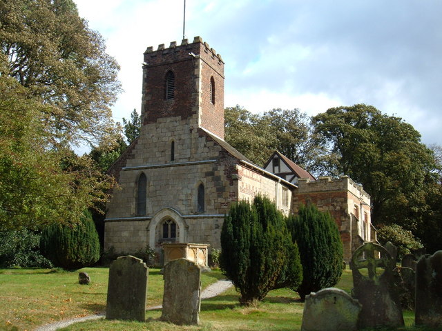 St Mary’s Church, Lockington | |
 Lockington Location within the East Riding of Yorkshire | |
| Population | 524 (2011 census)[1] |
| OS grid reference | SE995475 |
| • London | 165 mi (266 km) S |
| Civil parish |
|
| Unitary authority |
|
| Ceremonial county |
|
| Region |
|
| Country | England |
| Sovereign state | United Kingdom |
| Post town | DRIFFIELD |
| Postcode district | YO25 |
| Dialling code | 01430 |
| Police | Humberside |
| Fire | Humberside |
| Ambulance | Yorkshire |
| UK Parliament | |
The civil parish is formed by the villages of Lockington and Aike and the hamlet of Thorpe. According to the 2011 UK census the population of Lockington parish was 524,[1] a decrease on the 2001 UK census figure of 542.[2] There were 247 separate households.[1] However, since this census, recent housing developments have occurred.
The parish church of St Mary is a Grade I listed building.[3]
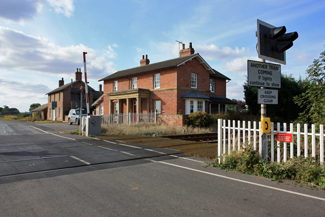
The A164 road and the Yorkshire Coast railway line from Hull to Scarborough both pass through the parish. Until 13 June 1960 Lockington railway station operated on the line.[4] The level crossing adjacent to the station was the scene of a fatal accident on 26 July 1986.[5]
In 1823 Lockington was in the civil parish of Lockington and of Kilnwick, in the Wapentake of Harthill. A National School existed in the village. Population was 491, with occupations including thirteen farmers, two carpenters, two shoemakers, a blacksmith, a tailor, a bricklayer, a corn miller, and the landlord of The Buck public house. Residents included the parish clerk, a schoolmaster, and a gentleman. A carrier operated between the village and Hull and Beverley once a week.[6]
References
- UK Census (2011). "Local Area Report – Lockington Parish (1170211218)". Nomis. Office for National Statistics. Retrieved 21 February 2018.
- UK Census (2001). "Local Area Report – Lockington Parish (00FB089)". Nomis. Office for National Statistics. Retrieved 2 March 2020.
- Historic England. "Church of St Mary (1310465)". National Heritage List for England. Retrieved 6 February 2013.
- Butt, R. V. J. (October 1995). The Directory of Railway Stations: details every public and private passenger station, halt, platform and stopping place, past and present (1st ed.). Sparkford: Patrick Stephens Ltd. ISBN 978-1-85260-508-7. OCLC 60251199. OL 11956311M.
- "Report on the Derailment that occurred on 26th July 1986 at Lockington Level Crossing in the Eastern Region British Railways". Department of Transport. The Railways Archive. 21 August 1987. Retrieved 17 October 2007.
- Baines, Edward (1823). History, Directory and Gazetteer of the County of York. pp. 363, 364.
- Gazetteer — A–Z of Towns Villages and Hamlets. East Riding of Yorkshire Council. 2006. p. 8.
External links
 Media related to Lockington at Wikimedia Commons
- Historic England. "St Mary's Church (1310465)". National Heritage List for England.
- Village website
- Lockington in the Domesday Book
Другой контент может иметь иную лицензию. Перед использованием материалов сайта WikiSort.org внимательно изучите правила лицензирования конкретных элементов наполнения сайта.
WikiSort.org - проект по пересортировке и дополнению контента Википедии