world.wikisort.org - United_Kingdom
Hannington is a village and civil parish in Wiltshire, England, two miles northwest of Highworth, and now part of the Borough of Swindon. The parish includes the hamlets of Hannington Wick (north of Hannington village) and Swanborough (south, on the border with Highworth parish). The nearest town is Swindon 5.5 miles (9.2 kilometres) and the County town of Wilshire, Trowbridge, is 29.5 miles (47.6 kilometres). The River Thames forms both the northern boundary of the parish and the county boundary with Gloucestershire.
| Hannington | |
|---|---|
 Hannington Hall | |
 Hannington Location within Wiltshire | |
| Population | 240 (in 2011)[1] |
| OS grid reference | SU175933 |
| Civil parish |
|
| Unitary authority |
|
| Shire county |
|
| Ceremonial county |
|
| Region | |
| Country | England |
| Sovereign state | United Kingdom |
| Post town | SWINDON |
| Postcode district | SN6 |
| Dialling code | 01793 |
| Police | Wiltshire |
| Fire | Dorset and Wiltshire |
| Ambulance | South Western |
| UK Parliament |
|
John Marius Wilson of the Imperial Gazetteer of England and Wales in 1870 described the village of Hannington as:
A village and a parish in Highworth district, Wilts. The village stands 2 miles W by N of Highworth, 2 S of the river Thames at the boundary with Gloucester, and 7 NE of Swindon Junction r. station; is a pretty place, built in the form of the letter Y; and has a post office under Swindon.[2]
Demographics
Population
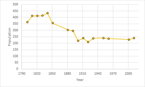
The parish of Hannington has a population of 240[3] 127 males and 113 females according to the most recent census data (2011).[4] At the height of the village's population in 1881 433 people lived in Hannington. However, since the industrial revolution that boomed in cities, such as nearby Swindon the population has steadily declined. Since 1940's the villages population has plateaued at 250 mark; in last 130 years the population has all but halved.

Occupations
The occupation for the village as of 1881[5] are shown in the graph (left), these have been divided into male and female with designated colours. Occupations at the time of the 1881 census were dominated by agriculture with 46 people; with the vast majority being male. Domestics services were all but exclusive to women due to the culture and the views of time. Census data in 1881 was recorded by the local priest or tax collector, many at the time were unemployed or carried out illegal activities.
Hannington Hall
Hannington Hall is a Grade II* listed country house built in 1653.[6] Hannington Hall has been a centre piece of the village since Sir Thomas Freke commissioned and paid for the construction. The Land and surrounding parsonages had been in the family name since 1603. The grounds of hall are still dotted with buildings associated to the running of the estate. Structures as Victorian stable block (Grade II* listed)[7]
St John the Baptist

St John the Baptist Church is the only religious building located in the local area, serving the population of Lushill and Cannington Wick as well as Hannington. However the church was originally named after Saint David and remains on the site point to a previous church building being situated on the land.[8]
Transport

The minor road running through the village connects to the B4019 Blunsdon-Highworth road to the south, giving access to the M4 motorway via the A419. The road north through Hannington Wick continues to Kempsford, and another minor road leads northwest to Castle Eaton.
The village has been without access to the rail network since 1962[9] when the Highworth branch line closed following declining passenger numbers. The branch from Swindon to Highworth was opened in 1883, over forty years after the main line was built through Swindon.[10] Hannington station was about a mile southeast of the village, near the Blunsdon to Highworth road;[11] there were other intermediate stations at Stratton and Stanton Fitzwarren.
Public Houses
Hannington's local inn is the Jolly Tar. However alternate pubs such as The Freke Arms are also situated in the parish. The Freke Family of Hannington built the pub in the early 19th century.[12]
Notable people
- Thomas Freke (1660–1721)[13]
References
- "Wiltshire Community History - Census". Wiltshire Council. Retrieved 15 August 2015.
- Marius, John (1870–1872). Imperial Gazetteer of England and Wales. Edinburgh: A. Fullerton & Co.
- "Hannington Census Information". 2011. Retrieved 17 March 2017.
- "Hanning (Parish): Key Figures for 2011 Census: Key Statistics". Neighborhood Statistics. Office for National Statistics. Retrieved 2 February 2017.
- "Occupation data classified into the 24 1881 'Orders', plus sex". www.visionofbritain.org.uk. Retrieved 29 March 2017.
- Historic England. "Hannington Hall (1023333)". National Heritage List for England. Retrieved 15 August 2015.
- "Hannington Conservation Area Appraisal and Management Plan" (PDF). Swindon County Council. 10 February 2009. Retrieved 20 February 2017.[permanent dead link]
- "St John's Hannington - St Michael and All Angels, Highworth". www.stmichaelshighworth.co.uk. Retrieved 29 March 2017.
- "Geograph:: Disused station platform, Hannington... (C) Vieve Forward". www.geograph.org.uk. Retrieved 17 March 2017.
- G, Heathcliffe (1984). "Highworth Light Railway". Highworth Historical Society. Retrieved 17 March 2017.
{{cite web}}: CS1 maint: url-status (link) - "Ordnance Survey One-inch sheet 252: Swindon". National Library of Scotland. 1896. Retrieved 9 February 2021.
- "Freke Arms pub and restaurant in Wiltshire. Great food, beer served in a country pub atmosphere". Freke Arms pub and restaurant in Wiltshire. Great food, beer served in a country pub atmosphere. Retrieved 29 March 2017.
- "FREKE, Thomas II (1660-1721), of Hannington, Wilts. | History of Parliament Online". www.historyofparliamentonline.org. Retrieved 29 March 2017.
External links
- Hannington at genuki.org.uk
![]() Media related to Hannington, Wiltshire at Wikimedia Commons
Media related to Hannington, Wiltshire at Wikimedia Commons
Другой контент может иметь иную лицензию. Перед использованием материалов сайта WikiSort.org внимательно изучите правила лицензирования конкретных элементов наполнения сайта.
WikiSort.org - проект по пересортировке и дополнению контента Википедии