world.wikisort.org - United_Kingdom
Garton on the Wolds is a village and civil parish on the Yorkshire Wolds in the East Riding of Yorkshire, England. It is situated approximately 3 miles (5 km) north-west of Driffield town centre and lies on the A166 road.
| Garton on the Wolds | |
|---|---|
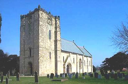 St Michael and All Angels' Church, Garton on the Wolds, 2004 | |
 Garton on the Wolds Location within the East Riding of Yorkshire | |
| Population | 348 (2011 census)[1] |
| OS grid reference | SE983594 |
| • London | 170 mi (270 km) S |
| Civil parish |
|
| Unitary authority | |
| Ceremonial county | |
| Region | |
| Country | England |
| Sovereign state | United Kingdom |
| Post town | DRIFFIELD |
| Postcode district | YO25 |
| Dialling code | 01377 |
| Police | Humberside |
| Fire | Humberside |
| Ambulance | Yorkshire |
| UK Parliament | |
Background
The civil parish is formed by the village of Garton on the Wolds and the hamlet of Elmswell. According to the 2011 UK Census, Garton parish had a population of 348,[1] an increase on the 2001 UK Census figure of 299.[2] On 1 April 1935 the parish of "Garton on the Wolds" was abolished and merged with Emswell with Little Driffield to form "Garton" parish.[3] The parish council is still called "Garton on the Wolds Parish Council".[4]
St Michael's and All Angels

Garton's church, St Michael's and All Angels, was designated a Grade I listed building in 1966 and is now recorded in the National Heritage List for England, maintained by Historic England.[5] It is on the Sykes Churches Trail devised by the East Yorkshire Churches Group.[6]
The church dates back to Norman times, circa 1132. In the 19th century it was restored by John Loughborough Pearson, with funding from Sir Tatton Sykes, 4th Baronet of nearby Sledmere House. Later his son, Sir Tatton Sykes, 5th Baronet, employed George Edmund Street to furnish the church.[6] It was eulogised by Nicholas Pevsner and is a popular visitor attraction due to its unique interior; the walls and ceilings are decorated in colourful murals depicting various biblical scenes, in sharp contrast to the stark interior of many other churches, and it has highly geometric floors in the altar and nave.[7] The mosaics in the sacristy are in the Cosmati style.
In 1823 Garton parish was in the Wapentake of Dickering, and the Liberty of St Peter. There existed a Methodist chapel, and a school which was partly supported by revenue from shares in the Driffield Navigation. Population at the time was 357. Occupations included twelve farmers, three tailors, two butchers, two grocers, two wheelwrights, a blacksmith, a boot & shoe maker, and the landlords of The Three Tuns and The Chase Inn public houses. There was also a schoolmaster and five gentlemen.[8]
Garton was served by Garton railway station on the Malton and Driffield Railway between 1853 and 1950.[9]
References
- UK Census (2011). "Local Area Report – Garton Parish (1170211185)". Nomis. Office for National Statistics. Retrieved 18 February 2018.
- UK Census (2001). "Local Area Report – Garton Parish (00FB056)". Nomis. Office for National Statistics. Retrieved 26 February 2020.
- "Relationships and Changes Garton CP through time". A Vision of Britain through Time. Retrieved 30 July 2019.
- "Home". Garton on the Wolds Parish Council. Retrieved 30 July 2019.
- Historic England. "The Church of St Michael (1160977)". National Heritage List for England. Retrieved 27 June 2013.
- "Sykes Churches Trail Southern Route". Beverley, East Yorkshire: East Yorkshire Historic Churches Group.
- Pevsner, Nikolaus; Neave, David (2002) [1972]. Yorkshire: York and the East Riding: The Buildings of England (2nd ed.). Yale University Press. ISBN 0-300-09593-7.
- Baines, Edward (1823). History, Directory and Gazetteer of the County of York. p. 209.
- Butt, R. V. J. (October 1995). The Directory of Railway Stations: details every public and private passenger station, halt, platform and stopping place, past and present (1st ed.). Sparkford: Patrick Stephens Ltd. ISBN 978-1-85260-508-7. OCLC 60251199. OL 11956311M.
- Gazetteer – A–Z of Towns Villages and Hamlets. East Riding of Yorkshire Council. 2006. p. 6.
External links
![]() Media related to Garton-on-the-Wolds at Wikimedia Commons
Media related to Garton-on-the-Wolds at Wikimedia Commons
- Garton on the Wolds in the Domesday Book
- Garton on the Wolds Parish Council
- Garton on the Wolds CE Primary School
Authority control | |
|---|---|
| General |
|
| National libraries | |
Другой контент может иметь иную лицензию. Перед использованием материалов сайта WikiSort.org внимательно изучите правила лицензирования конкретных элементов наполнения сайта.
WikiSort.org - проект по пересортировке и дополнению контента Википедии