world.wikisort.org - United_Kingdom
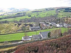
Crawleyside is a village in County Durham, in England. It is situated to the north of Stanhope, in Weardale.[1] In the 2001 census Crawleyside had a population of 170.[2]
| Crawleyside | |
|---|---|
 Crawleyside | |
 Crawleyside Location within County Durham | |
| Population | 170 (2001 census) |
| OS grid reference | NY993402 |
| Civil parish | |
| Unitary authority |
|
| Shire county |
|
| Region |
|
| Country | England |
| Sovereign state | United Kingdom |
| Post town | Bishop Auckland |
| Postcode district | DL13 |
| Dialling code | 01388 |
| Police | Durham |
| Fire | County Durham and Darlington |
| Ambulance | North East |
| UK Parliament |
|
The Crawley Edge Cairns, in a field to the west of the village are a series of forty-two Bronze Age cairns.[3]
References
- Ordnance Survey: Landranger map sheet 91 Appleby-in-Westmorland (Brough & Kirkby Stephen) (Map). Ordnance Survey. 2014. ISBN 9780319231302.
- "Wear Valley Settlement Summary Sheets" (PDF). Durham County Council. Archived from the original (PDF) on 7 October 2007. Retrieved 14 October 2016.
- "PastScape Record: MONUMENT NO. 20163". English Heritage. 2007. Retrieved 22 February 2015.
External links
![]() Media related to Crawleyside at Wikimedia Commons
Media related to Crawleyside at Wikimedia Commons
Текст в блоке "Читать" взят с сайта "Википедия" и доступен по лицензии Creative Commons Attribution-ShareAlike; в отдельных случаях могут действовать дополнительные условия.
Другой контент может иметь иную лицензию. Перед использованием материалов сайта WikiSort.org внимательно изучите правила лицензирования конкретных элементов наполнения сайта.
Другой контент может иметь иную лицензию. Перед использованием материалов сайта WikiSort.org внимательно изучите правила лицензирования конкретных элементов наполнения сайта.
2019-2025
WikiSort.org - проект по пересортировке и дополнению контента Википедии
WikiSort.org - проект по пересортировке и дополнению контента Википедии