world.wikisort.org - United_Kingdom
Congerstone (/ˈkʌndʒəstən/) is a small settlement in Leicestershire, England.[1] It is three miles north west of Market Bosworth, of which it was historically a daughter parish. It is near the Ashby-de-la-Zouch Canal and the A444 road.
| Congerstone | |
|---|---|
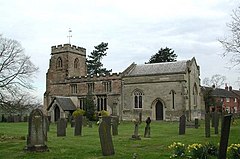
 St Mary's Parish Church | |
 Congerstone Location within Leicestershire | |
| OS grid reference | SK3605 |
| Shire county | |
| Region | |
| Country | England |
| Sovereign state | United Kingdom |
| Post town | Nuneaton |
| Postcode district | CV13 |
| Police | Leicestershire |
| Fire | Leicestershire |
| Ambulance | East Midlands |
| UK Parliament |
|
The village's name derives from the Old English cyning-tūn meaning 'farm/settlement of a king'.[2]
The Grade II* listed parish church of St Mary the Virgin dates back to 1179, although the current building is largely from the 16th century and was remodelled in the 19th century. [3] The patron of the church was formerly the Curzon family of Earl Howe who also helped fund the village school. [4] The church includes the tomb of Georgiana, Countess Howe, first wife of Richard Curzon, 4th Earl Howe, with a monument by Sir George Frampton. [5]
The village has one school, Congerstone Primary School, on Shackerstone Road.
External links
References
- OS Explorer Map 232 : Nuneaton & Tamworth: (1:25 000) :ISBN 0 319 46404 0
- "Key to English Place-names". kepn.nottingham.ac.uk. Archived from the original on 10 August 2021. Retrieved 19 August 2021.
- "Church of St Mary the Virgin A Grade II* Listed Building in Congerstone, Leicestershire". British Listed Buildings. Archived from the original on 15 June 2020. Retrieved 15 June 2020.
- "Compton-Dundon - Congresbury Pages 675-678 A Topographical Dictionary of England. Originally published by S Lewis, London, 1848". British History Online. Archived from the original on 15 June 2020. Retrieved 15 June 2020.
- "About us - Congerstone: St Mary the Virgin". A Church Near You. Archived from the original on 15 June 2020. Retrieved 15 June 2020.
Другой контент может иметь иную лицензию. Перед использованием материалов сайта WikiSort.org внимательно изучите правила лицензирования конкретных элементов наполнения сайта.
WikiSort.org - проект по пересортировке и дополнению контента Википедии