world.wikisort.org - United_Kingdom
Calder Vale is an English village, located on the edge of the Forest of Bowland[1] in Lancashire. It lies on the River Calder in a deep valley with only a single road providing vehicular access. The name Calder is thought to be derived from the Old Norse kaldr ("cold").
| Calder Vale | |
|---|---|
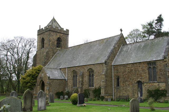 St. John's church | |
 Calder Vale Location in Wyre Borough 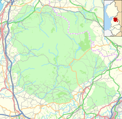 Calder Vale Location in the Forest of Bowland  Calder Vale Location within Lancashire | |
| Population | 2,148 (2011.Ward) |
| OS grid reference | SD535455 |
| Civil parish | |
| District |
|
| Shire county |
|
| Region |
|
| Country | England |
| Sovereign state | United Kingdom |
| Post town | PRESTON |
| Postcode district | PR3 |
| Dialling code | 01995 |
| Police | Lancashire |
| Fire | Lancashire |
| Ambulance | North West |
| UK Parliament |
|
The village was founded by Quakers Jonathan and Richard Jackson,[2] and in 1835 a cotton-weaving mill — the Lappet Mill — was built, powered by the River Calder. The mill and mill pond still exist and Lappet Mill is still working as a cotton mill. One of its main products is the red, black and white checked cloth used for Arab headscarves and it was said that Yasser Arafat's headdresses were made at the Mill.[3] The Jackson brothers also built many of the terraced houses still in occupation close to the mills.[4]
The church of St. John the Evangelist lies high above the village, linked to it by a woodland footpath. It was consecrated on 12 August 1863.[5] It serves the adjacent village of Oakenclough, in addition to Calder Vale.
The village also contains a primary school, Calder Vale Church of England School, which was built concurrently with the church.[6] It is a small school consisting of two teachers and about 30 pupils, and it is situated next door to St. John's Church, the two being very closely linked.
There is also a village hall and a Methodist chapel in the village centre. The village also has Scouts and Brownies, a Women's Institute, who meets monthly in the village hall, and a Village Club.
Every Sunday in May the villagers get together and organise the 'BlueBell Teas'[7] (where cakes, sandwiches and local produce are sold for charity, and for the upkeep of the village hall and 'mission room'). On the second Saturday of June every year, there is a village festival.
The elected Member for Wyre Borough Council's Calder Ward is Councillor David Meirion Williams.[8]
Governance
The village falls in the electoral ward of Calder. This ward stretches south-east to Barnacre. The total ward population at the 2011 census was 2,148.[9]
Gallery
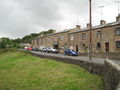 The terraced housing that makes up the village's Victoria Terrace. The village hall, with its green sign, is in view
 Another flank of terraced houses, on the aptly named Long Row, stands next to the church
 Lappet Mill


See also
- Listed buildings in Barnacre-with-Bonds
References
- "WELCOME TO CALDER VALE, BLEASDALE AND BARNACRE" (PDF). Forestofbowland.com. Retrieved 22 January 2022.
- "Calder Vale at ForestofBowland.com". Archived from the original on 22 September 2008. Retrieved 7 September 2008.
- "Geograph:: Lappet Mill at Calder Vale © David Medcalf". Geograph.org.uk. Retrieved 22 January 2022.
- "Calder Vale walk". Lancashire Telegraph. Retrieved 22 January 2022.
- "Wyre Borough Council - History of Wyre - Calder Vale". 17 March 2007. Archived from the original on 17 March 2007. Retrieved 22 January 2022.
- "Home | Calder Vale St John C of E Primary School". Caldervale.lancs.sch.uk. Retrieved 22 January 2022.
- "WI Caldervale". Wicaldervale1.yolasite.com. Retrieved 22 January 2022.
- "Wyre Councillor David Williams". Wyre.gov.uk. Retrieved 22 January 2022.
- "Ward population 2011". Ukcensusdata.com. Retrieved 4 June 2015.
Further reading
- Wilcock, Jack (2012). The Story of Calder Vale and Oakenclough: A Lancashire Village Victorian Diary. ISBN 978-0-9531719-3-4.
External links
Другой контент может иметь иную лицензию. Перед использованием материалов сайта WikiSort.org внимательно изучите правила лицензирования конкретных элементов наполнения сайта.
WikiSort.org - проект по пересортировке и дополнению контента Википедии