world.wikisort.org - United_Kingdom
Blairmore is a village located on the Cowal peninsula in Argyll and Bute, Scotland. Blairmore lies within the Loch Lomond and The Trossachs National Park.[1] It is situated on the western shore of Loch Long and around 1 mile (1.6 km) north of Strone. The village was largely built during the Victorian era and has a small wooden pier which dates to 1855.[2][3]
Blairmore
| |
|---|---|
 Blairmore Village Hall and shops. | |
 Blairmore Location within Argyll and Bute | |
| OS grid reference | NS 19200 82500 |
| Council area |
|
| Lieutenancy area |
|
| Country | Scotland |
| Sovereign state | United Kingdom |
| Post town | DUNOON, ARGYLL |
| Postcode district | PA23 |
| Dialling code | 01369 |
| UK Parliament |
|
| Scottish Parliament |
|
Gallery
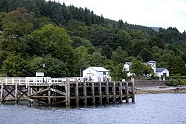 Blairmore Pier
 Paddle steamer Waverley about to leave Blairmore pier
 Blairmore Pier
 Blairmore Pier - geograph.org.uk - 758676


References
- "Archived copy" (PDF). Archived from the original (PDF) on 14 June 2019. Retrieved 17 January 2017.
{{cite web}}: CS1 maint: archived copy as title (link) - "History of Blairmore in Argyll and Bute | Map and description". Visionofbritain.org.uk. Retrieved 5 April 2012.
- "Blairmore Pier, Near Strone". The Glasgow Herald. 11 July 1855. p. 1. Retrieved 5 April 2012.
External links
- Map sources for Blairmore, Argyll
- Blairmore Gallery - website
- Blairmore and Strone Golf Club - website
- Blairmore Heritage - website
- Loch Lomond and The Trossachs National Park - website
| Wikimedia Commons has media related to Blairmore, Argyll and Bute. |
This Argyll and Bute location article is a stub. You can help Wikipedia by expanding it. |
Текст в блоке "Читать" взят с сайта "Википедия" и доступен по лицензии Creative Commons Attribution-ShareAlike; в отдельных случаях могут действовать дополнительные условия.
Другой контент может иметь иную лицензию. Перед использованием материалов сайта WikiSort.org внимательно изучите правила лицензирования конкретных элементов наполнения сайта.
Другой контент может иметь иную лицензию. Перед использованием материалов сайта WikiSort.org внимательно изучите правила лицензирования конкретных элементов наполнения сайта.
2019-2026
WikiSort.org - проект по пересортировке и дополнению контента Википедии
WikiSort.org - проект по пересортировке и дополнению контента Википедии