world.wikisort.org - United_Kingdom
Aberford is a village and civil parish on the eastern outskirts of the City of Leeds metropolitan borough in West Yorkshire, England. It had a population of 1,059 at the 2001 census,[2] increasing to 1,180 at the 2011 Census.[1] It is situated 10 miles (15.5 km) east, north east of Leeds city centre in the LS25 Leeds postcode area.[3]
This article needs additional citations for verification. (March 2019) |
| Aberford | |
|---|---|
 Boundary marker | |
 Aberford  Aberford Location within West Yorkshire | |
| Population | 1,180 (2011 census)[1] |
| OS grid reference | SE434373 |
| • London | 165 mi (266 km) SSE |
| Civil parish |
|
| Metropolitan borough |
|
| Metropolitan county | |
| Region |
|
| Country | England |
| Sovereign state | United Kingdom |
| Post town | LEEDS |
| Postcode district | LS25 |
| Dialling code | 0113 |
| Police | West Yorkshire |
| Fire | West Yorkshire |
| Ambulance | Yorkshire |
| UK Parliament |
|
Etymology
The name 'Aberford' comes from the Old English woman's name Ēadburg and ford, which, then as now, meant 'ford'. The name meant 'Eadburg's ford'.[4] This suggests the settlement's once-strategic importance.[5] The name was recorded as Ædburford in 1176 and Ædburgford in 1177, Ebberford in the 13th century and Aberford from 1208.[6]
History
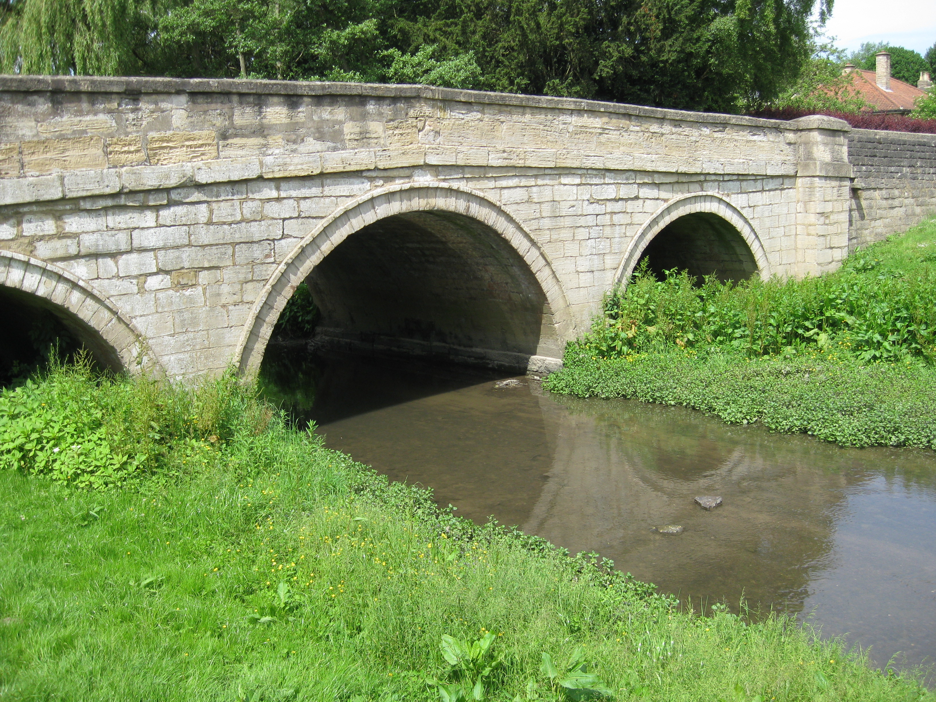
Aberford was where the ancient Great North Road crossed over the Cock River (now reduced in volume as the Cock Beck). Aberford was the midway point between London and Edinburgh, being around 200 miles (320 km) distant from each city until the construction of the A1(M) motorway bypass starting at Hook Moor.[7] On the north side of the river the Aberford Dykes earthworks were constructed to defend the crossing. The buried remains of a Roman fort have been found beneath Aberford House.[8] The current bridge dates from the 18th century.[9]
Aberford was in the ancient Kingdom of Elmet, the name given to the local parliamentary constituency. An Anglo-Saxon gold ring, inscribed with the name of King Alfred the Great's sister Æthelswith, was found in a ploughed field near the village in 1870. It was bequeathed by A.W. Franks to the British Museum in 1897.[10] In the 17th century the village was a major place for the manufacture of pins.[11]
Aberford's growth has historically been along the road and the village has developed a linear rather than nucleated profile.[12] Since the early 1990s much new housing has been constructed, as increasing affluence allows people to move away from city centres to rural and suburban areas.
Geology
Geologically, Aberford lies slightly east of the narrow basal sandstone boundary between the central Leeds' Coal Measures and much harder magnesian limestone deposits, and sits in an area shaped heavily by subsidence of the underlying Coal Measures.
Buildings
Aberford is considered "a place of special architectural and historic interest".[13] Some notable buildings are:
- St Ricarius Church. The parish church is an 1861 rebuilding of a 12th-century one.[14]
- The Gascoigne Almshouses designed by George Fowler Jones was built by sisters Mary Isabella and Elizabeth Gascoigne in 1844 to commemorate their father, Richard Oliver Gascoigne and two brothers who died in quick succession. They are grade II* listed buildings.[15]
- Aberford House is a classical 18th century mansion on Main Street.[16]
- The Swan Hotel, previously a staging post used by those travelling the Great North Road.[17]
- The Arabian Horse Inn is one of a very few public houses in the UK with this name, and a landmark with the conservation area.[18]
Aberford Church of England primary School is affiliated with the parish church adjacent to it. The school was originally a tithe barn and is owned by the Archdeacon of York following its transfer from the Vicar of Aberford. Previously, it and much of the village was owned by Oriel College, Oxford, which also received tithes from Aberford.[19][20] At the northern boundary is the A64 road from Leeds to York and Scarborough. At the south end of Aberford is what used to be Hicklam Mill Farm now a small certified caravan and camping site.
Parlington Estate
The Parlington Estate holds a monument to the independence of the United States, built by Sir Thomas Gascoigne, last of the Gascoigne family blood line. It is inscribed on both elevations with the phrase "Liberty in N.America Triumphant MDCCLXXXIII". The 'Dark Arch', a short curved tunnel along Parlington Lane is reputed to be haunted. It was built c. 1813–14 to shield the residents of Parlington Hall from traffic passing along Parlington Lane, mostly horse drawn coal traffic on its way to the village distribution point for onward travel into the local market.
The lane was later developed for the private Aberford Railway commonly called the "Fly Line" to transport the coal from the Gascoigne's pits to Garforth.[21][22] The railway closed in 1924.[23] Parlington Hall was left to run to ruins after the death of Col F. C. T. Gascoigne in 1905, the hall was largely demolished in the 1950s and 1960s, though the west wing is still intact. The estate was used by the army during the First and Second World Wars. The structures, built during the Second World War and still in existence (2009), were constructed by the soldiers of No.3 Vehicle Repair Depot, part of Royal Army Ordnance Corps.
Nellie's Tree is a local landmark that was voted English and British Tree of the Year for 2018.[24]
Gallery
 St Ricarius Church
 The Swan a former public house
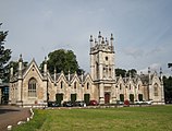 Gascoigne Almshouses
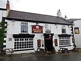 The Arabian Horse public house
 Aberford Bridge over the Cock Beck. The arches show the former width
 The Royal Oak a former public house


Location grid
Places adjacent to Aberford | ||||||||||||||||
|---|---|---|---|---|---|---|---|---|---|---|---|---|---|---|---|---|
| ||||||||||||||||
See also
- Listed buildings in Aberford
References
- UK Census (2011). "Local Area Report – Aberford Parish (E04000186)". Nomis. Office for National Statistics. Retrieved 29 March 2019.
- UK Census (2001). "Local Area Report – Aberford Parish (00DA001)". Nomis. Office for National Statistics. Retrieved 29 March 2019.
- ANDP 2018, p. 7.
- Harry Parkin, Your City's Place-Names: Leeds, English Place-Name Society City-Names Series, 3 (Nottingham: English Place-Names Society, 2017), p. 11.
- ACAAMP 2011, pp. 5–6.
- Watts, Victor (2007). The Cambridge Dictionary of English Place-Names. Cambridge University Press. p. 1. ISBN 978-0521168557.
- "Aberford & District Parish Council | Aberford". aberford-pc.gov.uk. Retrieved 29 March 2019.
- ACAAMP 2011, p. 5.
- "Aberford Bridge". British Listed Buildings. Retrieved 14 April 2017.
- "Æthelswith Ring". British Museum Collection Online. Retrieved 22 September 2017.
- ACAAMP 2011, p. 6.
- ACAAMP 2011, p. 4.
- ACAAMP 2011, p. 1.
- "Parish Church of St Ricarius or St Riquier". British Listed Buildings. Retrieved 14 April 2017.
- "Gascoigne Almshouses and Attached Wardens Cottage". British Listed Buildings. Retrieved 14 April 2017.
- "Aberford House". British Listed Buildings. Retrieved 14 April 2017.
- "The Swan Hotel". British Listed Buildings. Retrieved 14 April 2017.
- ACAAMP 2011, p. 11.
- Piper, Marolyn (4 December 2006). "The Lost Village of Hillam Burchard". Aberford People. Retrieved 29 March 2019.
- Rogers, Joseph (2021). Tithe barns. Stroud, Gloucestershire. p. 15. ISBN 978-1-4456-9285-2. OCLC 1242784225.
- Historic England. "Garforth Station Road Bridge (1586037)". Research records (formerly PastScape). Retrieved 29 March 2019.
- "Parlington Leeds Pattern Book" (PDF). parlingtonvillage.co.uk. M & G Real Estate. June 2018. p. 11. Retrieved 29 March 2019.
- ACAAMP 2011, p. 7.
- "Sweetheart beech wins Tree of the Year". BBC News. 18 October 2018. Retrieved 14 November 2018.
Sources
- Aberford Conservation Area Appraisal and Management Plan (PDF). www.leeds.gov.uk (Report). Leeds City Council. 30 May 2011. Retrieved 29 March 2019.
- Aberford Neighbourhood Development Plan 2018-2028 (PDF). www.leeds.gov.uk (Report). Aberford District Council. 8 March 2018. Retrieved 29 March 2019.
External links
- Aberford community website with local news and parish council information
- A comprehensive History of Parlington Hall, and features associated with the hall like the Ice House, the Dark Arch and the Triumphal Arch.'
- Leeds's geology
- Aberford C of E School
- Roman Roads in Britain (large map, recommended that this is opened in a separate window)
- Details on the Great North Road
- The Aberford Railway (Fly Line), at the LNER Encyclopedia
- Photos of Aberford and surrounding area on geograph
- Leodis View photographs of Aberford on the Leeds photographic archive.
Authority control | |
|---|---|
| General | |
| National libraries | |
Другой контент может иметь иную лицензию. Перед использованием материалов сайта WikiSort.org внимательно изучите правила лицензирования конкретных элементов наполнения сайта.
WikiSort.org - проект по пересортировке и дополнению контента Википедии