world.wikisort.org - Vereinigtes_Königreich
Birchwood ist eine Gemeinde (civil parish) in der englischen Unitary Authority Warrington in der Region North West England. Im Jahr 2001 zählte sie 11.395 Einwohner.[1] Birchwood ist ein östlicher Vorort von Warrington.
| Birchwood | |||
|---|---|---|---|
 | |||
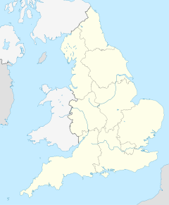
| Koordinaten | 53° 24′ N, 2° 35′ W | ||
| |||
| Traditionelle Grafschaft | |||
| Einwohner | 11.395 (Stand: 2001) | ||
| Verwaltung | |||
| Post town | WARRINGTON | ||
| Postleitzahlenabschnitt | WA3 | ||
| Vorwahl | 019258 | ||
| Landesteil | England | ||
| Region | North West England | ||
| Zeremonielle Grafschaft | Cheshire | ||
| Unitary authority | Warrington | ||
| Civil Parish | Birchwood | ||
| Britisches Parlament | Warrington North | ||
Einzelnachweise
- National Statistics: http://neighbourhood.statistics.gov.uk/dissemination/LeadTableView.do?a=3&b=790885&c=birchwood&d=16&e=15&g=388089&i=1001x1003x1004&m=0&r=1&s=1197034486367&enc=1&dsFamilyId=781
На других языках
- [de] Birchwood (Warrington)
[en] Birchwood
Birchwood is a town in the Borough of Warrington, Cheshire, England with a population of 11,395 (as at the 2001 census). Although physically and administratively part of Warrington, the civil parish council has named itself a town council.[1] Historically part of Lancashire, it was built during the time of much expansion in Warrington as it became a "new town". Birchwood is separated into three residential estates: Gorse Covert (grid ref SJ665925, population 2,790), Oakwood (grid ref SJ656914, population 4,381) and Locking Stumps (grid ref SJ645918, population 2,759), with all the main facilities grouped around the centre.Текст в блоке "Читать" взят с сайта "Википедия" и доступен по лицензии Creative Commons Attribution-ShareAlike; в отдельных случаях могут действовать дополнительные условия.
Другой контент может иметь иную лицензию. Перед использованием материалов сайта WikiSort.org внимательно изучите правила лицензирования конкретных элементов наполнения сайта.
Другой контент может иметь иную лицензию. Перед использованием материалов сайта WikiSort.org внимательно изучите правила лицензирования конкретных элементов наполнения сайта.
2019-2025
WikiSort.org - проект по пересортировке и дополнению контента Википедии
WikiSort.org - проект по пересортировке и дополнению контента Википедии