world.wikisort.org - Thailand
Pa Sak (Thai: ป่าสัก) is a tambon (subdistrict) of Chiang Saen District, in Chiang Rai Province, Thailand. In 2019 it had a total population of 7,877 people.[1]
Pa Sak
ป่าสัก | |
|---|---|
Tambon | |
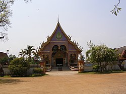
 Wat Ban Pang Mo Puang | |
| Country | |
| Province | Chiang Rai |
| Amphoe | Chiang Saen |
| Population (2019) | |
| • Total | 7,877 |
| Time zone | UTC+7 (TST) |
| Postal code | 57150 |
| TIS 1099 | 570802 |
History
The subdistrict was created effective September 15, 1979 by splitting off 9 administrative villages from Si Don Mun.[2]
Administration
Central administration
The tambon is subdivided into 13 administrative villages (muban).
| No. | Name | Thai |
|---|---|---|
| 1. | Ban Mae Kham Kaset | บ้านแม่คำเกษตร |
| 2. | Ban Mae Kham Nong Bua | บ้านแม่คำหนองบัว |
| 3. | Ban Pa Sak Noi | บ้านป่าสักน้อย |
| 4. | Ban Pa Daet | บ้านป่าแดด |
| 5. | Ban Nong Bua Sot | บ้านหนองบัวสด |
| 6. | Ban Pang Mo Puang | บ้านปางหมอปวง |
| 7. | Ban Doi Champi | บ้านดอยจำปี |
| 8. | Ban Doi Si Kaeo | บ้านดอยศรีแก้ว |
| 9. | Ban San Makhet | บ้านสันมะเค็ด |
| 10. | Ban Doi Kham | บ้านดอยคำ |
| 11. | Ban Mae Kham Tai | บ้านแม่คำใต้ |
| 12. | Ban Pa Sak Noi | บ้านป่าสักน้อย |
| 13. | Ban Pa Sak Noi | บ้านป่าสักน้อย |
Local administration
The whole area of the subdistrict is covered by the subdistrict administrative organization (SAO) Pa Sak (องค์การบริหารส่วนตำบลป่าสัก).
Landmarks
The historical site of Wat Pa Sak is located in this region.[3]
References
- "Population statistics 2019" (in Thai). Department of Provincial Administration. Retrieved 2020-12-17.
- "ประกาศกระทรวงมหาดไทย เรื่อง ตั้งและเปลี่ยนแปลงเขตตำบลในท้องที่อำเภอแม่สาย อำเภอเชียงแสน จังหวัดเชียงราย" (PDF). Royal Gazette (in Thai). 96 (177 ง): 3647–3654. 1979-10-16.
- "Wat Pa Sak, Chiang Saen - TripAdvisor". TripAdvisor. Retrieved 2018-11-02.
External links
Текст в блоке "Читать" взят с сайта "Википедия" и доступен по лицензии Creative Commons Attribution-ShareAlike; в отдельных случаях могут действовать дополнительные условия.
Другой контент может иметь иную лицензию. Перед использованием материалов сайта WikiSort.org внимательно изучите правила лицензирования конкретных элементов наполнения сайта.
Другой контент может иметь иную лицензию. Перед использованием материалов сайта WikiSort.org внимательно изучите правила лицензирования конкретных элементов наполнения сайта.
2019-2025
WikiSort.org - проект по пересортировке и дополнению контента Википедии
WikiSort.org - проект по пересортировке и дополнению контента Википедии