world.wikisort.org - Sri_Lanka
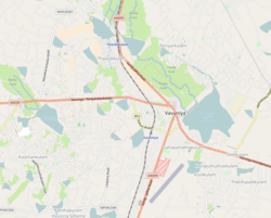
Koomankulam (Vavuniya-04 or Official Name 214F), (Tamil: கூமாங்குளம், romanized: Kūmāṅkuḷam; Sinhala: කුමාංකුලම්, romanized: kumāṁkulam) is a suburb and is considered to be the largest village in Sri Lanka. It is the most populated area in Vavuniya. Administered by Vavuniya South Tamil Pradeshiya Sabha.[1]
Koomankulam
கூமாங்குளம் කුමාංකුලම් | |
|---|---|
Suburb | |
 Koomankulam  Koomankulam  Koomankulam | |
| Coordinates: 8°46′34″N 80°27′28″E | |
| Country | Sri Lanka |
| Province | Northern Province, Sri Lanka |
| District | Vavuniya |
| Pradeshiya Sabha | Vavuniya South Tamil Pradeshiya Sabha |
| Weather | |
| Named for | Kūmā Tree |
| Government | |
| • Type | Pradeshiya Sabha |
| • Body | Grama Niladhari |
| Area | |
| • Total | 31.3 km2 (12.1 sq mi) |
| Elevation | 104 m (341 ft) |
| Population | |
| • Total | ~15,000 |
| Time zone | UTC+5:30 |
| Postal Code | 43000 |
| Area code | 024 |
Etymology

The village came to be known as Koomankulam due to the abundance of Kūmā trees in the area.
Location
Koomankulam is located 7.4 km (4.6 mi) away from Vanuniya. It is bordered to the north by Manipuram, to the east by Ganeshapuram, to the west by Pattanichipuliyankulam, and to the south by Nelukkulam.
Safety
Koomankulam is one of the most troubled places in Vavuniya. It is very difficult for women to walk outside at night. Village with a lot of fear of thieves
Education
Koomankulam Sithivinaygar Vidyalayam
References
- "Weather Forecast Koomankulam - Sri Lanka (Northern Province) : free 15 day weather forecasts". La Chaîne Météo (in French). Retrieved 2022-04-01.
Другой контент может иметь иную лицензию. Перед использованием материалов сайта WikiSort.org внимательно изучите правила лицензирования конкретных элементов наполнения сайта.
WikiSort.org - проект по пересортировке и дополнению контента Википедии