world.wikisort.org - Spagna
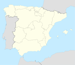
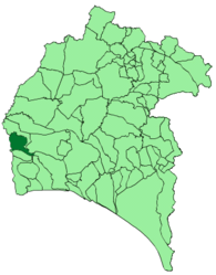
Sanlúcar de Guadiana è un comune spagnolo di 378 abitanti situato nella comunità autonoma dell'Andalusia.


|
Questa voce o sezione sull'argomento centri abitati della Spagna non cita le fonti necessarie o quelle presenti sono insufficienti.
|
| Sanlúcar de Guadiana comune | |||
|---|---|---|---|
| |||
| |||
| Localizzazione | |||
| Stato | |||
| Comunità autonoma | |||
| Provincia | |||
| Territorio | |||
| Coordinate | 37°28′18.12″N 7°28′00.12″W | ||
| Altitudine | 149 m s.l.m. | ||
| Superficie | 49 km² | ||
| Abitanti | 378 (2001) | ||
| Densità | 7,71 ab./km² | ||
| Comuni confinanti | Alcoutim (PT-08), Ayamonte, Cartaya, El Granado, San Silvestre de Guzmán, Villanueva de los Castillejos | ||
| Altre informazioni | |||
| Cod. postale | 21595 | ||
| Prefisso | (+34)... | ||
| Fuso orario | UTC+1 | ||
| Codice INE | 21065 | ||
| Targa | H | ||
| Cartografia | |||
 Sanlúcar de Guadiana | |||
 | |||
| Sito istituzionale | |||


Altri progetti
 Wikimedia Commons contiene immagini o altri file su Sanlúcar de Guadiana
Collegamenti esterni
- Sito ufficiale, su sanlucardeguadiana.es.
На других языках
[en] Sanlúcar de Guadiana
Sanlúcar de Guadiana is a localidad in the province of Huelva, Andalusia, Spain, situated near the Portugal–Spain border, 50 kilometres (31 mi) from the city of Huelva. The inhabitants are known as Sanluqueños. The village borders the Guadiana River, which is tidal at this point, but the higher parts of the village rise to an altitude of 149 metres (489 ft).[es] Sanlúcar de Guadiana
Sanlúcar de Guadiana es un municipio español de la provincia de Huelva, en la comunidad autónoma de Andalucía. Perteneciente a la comarca del Andévalo, cuenta con una población de 380 habitantes (INE 2021).[fr] Sanlúcar de Guadiana
Sanlúcar de Guadiana est une commune de la province de Huelva dans la communauté autonome d'Andalousie en Espagne.- [it] Sanlúcar de Guadiana
[ru] Санлукар-де-Гвадиана
Санлукар-де-Гвадиана (исп. Sanlúcar de Guadiana) — населённый пункт и муниципалитет в Испании, входит в провинцию Уэльва, в составе автономного сообщества Андалусия. Муниципалитет находится в составе района (комарки) Андевало. Занимает площадь 49 км². Население — 408 человек (на 2010 год). Расстояние — 55 км до административного центра провинции.Текст в блоке "Читать" взят с сайта "Википедия" и доступен по лицензии Creative Commons Attribution-ShareAlike; в отдельных случаях могут действовать дополнительные условия.
Другой контент может иметь иную лицензию. Перед использованием материалов сайта WikiSort.org внимательно изучите правила лицензирования конкретных элементов наполнения сайта.
Другой контент может иметь иную лицензию. Перед использованием материалов сайта WikiSort.org внимательно изучите правила лицензирования конкретных элементов наполнения сайта.
2019-2026
WikiSort.org - проект по пересортировке и дополнению контента Википедии
WikiSort.org - проект по пересортировке и дополнению контента Википедии