world.wikisort.org - Spagna
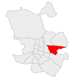
San Blas-Canillejas è uno dei distretti in cui è suddivisa la città di Madrid, in Spagna. Viene identificato col numero 20.
| San Blas-Canillejas distretto | |
|---|---|
| (20) San Blas-Canillejas | |
 | |
| Localizzazione | |
| Stato | |
| Comunità autonoma | |
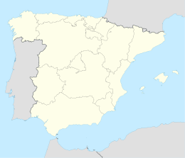
| Provincia | |
| Comune | Madrid |
| Territorio | |
| Coordinate | 40°25′33.6″N 3°36′45.95″W |
| Superficie | 22,36 km² |
| Abitanti | 157 367 |
| Densità | 7 037,88 ab./km² |
| Altre informazioni | |
| Fuso orario | UTC+1 |
| Cartografia | |
 San Blas-Canillejas | |
 | |
Geografia fisica
Il distretto si trova a est del centro della città.
Suddivisione
Il distretto è suddiviso amministrativamente in 8 quartieri (Barrios):
- Amposta
- Arcos
- Canillejas
- Hellín
- Rejas
- Rosas
- Salvador
- Simancas
Altri progetti
 Wikimedia Commons contiene immagini o altri file su San Blas
На других языках
[en] San Blas-Canillejas
San Blas-Canillejas is a district to the east of Madrid's city centre. The population of the district is estimated in 149,909.[1]- [it] San Blas-Canillejas
Текст в блоке "Читать" взят с сайта "Википедия" и доступен по лицензии Creative Commons Attribution-ShareAlike; в отдельных случаях могут действовать дополнительные условия.
Другой контент может иметь иную лицензию. Перед использованием материалов сайта WikiSort.org внимательно изучите правила лицензирования конкретных элементов наполнения сайта.
Другой контент может иметь иную лицензию. Перед использованием материалов сайта WikiSort.org внимательно изучите правила лицензирования конкретных элементов наполнения сайта.
2019-2026
WikiSort.org - проект по пересортировке и дополнению контента Википедии
WikiSort.org - проект по пересортировке и дополнению контента Википедии