world.wikisort.org - Spagna
Pájara è un comune spagnolo situato nella comunità autonoma delle Canarie, sull'isola di Fuerteventura. La sua popolazione è di 19.271 (2015), e la sua area è 383.52 km². Pájara è la municipalità più a sud ovest dell'isola. Pájara è inoltre la più grande municipalità dell'isola. Il piccolo porto di Ajuy è situato a nord della municipalità, vicino a Betancuria. La penisola di Jandía è parte della municipalità.
| Pájara comune | ||
|---|---|---|
 | ||
| Localizzazione | ||
| Stato | ||
| Comunità autonoma | ||
| Provincia | ||
| Territorio | ||
| Coordinate | 28°21′N 14°06′W | |
| Altitudine | 196 m s.l.m. | |
| Superficie | 383,52 km² | |
| Abitanti | 19 271 (2015) | |
| Densità | 50,25 ab./km² | |
| Comuni confinanti | Betancuria, Tuineje | |
| Altre informazioni | ||
| Cod. postale | 35628 | |
| Prefisso | (+34)... | |
| Fuso orario | UTC+0 | |
| Codice INE | 35015 | |
| Targa | GC | |
| Cartografia | ||
 Pájara | ||
| Sito istituzionale | ||
La città
La piccola città pittoresca di Pájara è un centro turistico della penisola di Jandia. Nonostante le sue dimensioni offre alcuni monumenti che vale sicuramente la pena di visitare. La Iglesia Nuestra Señora de la Regla è sicuramente uno di questi, costruita tra il 1687 e il 1711 è una delle più belle chiese che si possono visitare sull'isola. Sono molte le decorazioni e le pietre preziose che arricchiscono questa costruzione, di particolare rilievo la vergine che sta in piedi sull'altare e che fu portata sull'isola da dei facoltosi emigranti provenienti dal Messico.
Spazi naturali protetti
- Monumento naturale Ajuí: ospita sentimenti oceanici e fossili di animali marini già scomparsi e di grande interesse scientifico.
- Parco naturale di Jandía: abbraccia quasi tutta la totalità della penisola con lo stesso nome. Sono molte le specie animali in via di estinzione presenti in questo parco.
- Monumento naturale Montaña Cardón: di interesse scientifico per la sua ricchezza a livello naturale.
- Parco rurale di Betancuria: si estende tra i municipi di Betancuria, Puerto del Rosario, Antigua, Tuineje e Pájara. Il suo ecosistema favorisce la nascita e la crescita di uccelli acquatici.
- Regione naturale della Playa del Matorral: con solo 115 ettari, si tratta di un luogo di alto interesse scientifico.
Galleria d'immagini
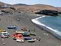 Spiaggia a Ajuy
 Spiaggia a El Cofete
 Chiesa Nuestra Señora de Regla, Pájara
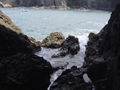 Spiaggia di Caleta Negra


Altri progetti
 Wikimedia Commons contiene immagini o altri file su Pájara
Collegamenti esterni
- Sito ufficiale, su pajara.es.
| Controllo di autorità | VIAF (EN) 58144648360178896934 |
|---|
На других языках
[de] Pájara
Pájara ist die südlichste der sechs Gemeinden der Kanareninsel Fuerteventura. Der gleichnamige Verwaltungssitz der Gemeinde ist recht wohlhabend, was aus den Einnahmen der großen Touristenzentren von Costa Calma bis Morro Jable resultiert.[en] Pájara
Pájara is a municipality in the southwestern portion of the island of Fuerteventura in the Province of Las Palmas in the Canary Islands as well as the name of its largest town. Its population is 20,931 (2013),[3] and the area is 383.52 km².[1] Pájara is both the southernmost and the westernmost municipality on the island. Pájara is also the largest municipality on the island. The largest towns in the municipality of Pájara are Morro Jable and Costa Calma, both situated on the coast. The small port Ajuy is situated in the north of the municipality, near Betancuria. The Jandía peninsula is part of the municipality.[es] Pájara
Pájara es una ciudad y municipio español perteneciente a la isla de Fuerteventura, en la provincia de Las Palmas, comunidad autónoma de Canarias.[1][fr] Pájara
Pájara est une commune de la communauté autonome des îles Canaries en Espagne. Elle est située au sud de l'île de Fuerteventura dans la province de Las Palmas.- [it] Pájara
[ru] Пахара
Пахара (исп. Pájara) — населённый пункт и муниципалитет в Испании, входит в провинцию Лас-Пальмас в составе автономного сообщества Канарские острова. Находится на острове Фуэртевентура. Занимает площадь 383,52 км². Население — 20622 человека (на 2010 год).Другой контент может иметь иную лицензию. Перед использованием материалов сайта WikiSort.org внимательно изучите правила лицензирования конкретных элементов наполнения сайта.
WikiSort.org - проект по пересортировке и дополнению контента Википедии