world.wikisort.org - Espagne
Masllorenç est une commune de la province de Tarragone, en Catalogne, en Espagne, de la comarque de Baix Penedès.
Cet article est une ébauche concernant une localité catalane.
Vous pouvez partager vos connaissances en l’améliorant (comment ?) selon les recommandations des projets correspondants.
| Masllorenç | ||||
 Héraldique |
||||
| Administration | ||||
|---|---|---|---|---|
| Pays | ||||
| Statut | Municipio | |||
| Communauté autonome | ||||
| Province | Province de Tarragone | |||
| Comarque | Baix Penedès | |||
| Code postal | 43718 | |||
| Démographie | ||||
| Population | 508 hab. () | |||
| Densité | 78 hab./km2 | |||
| Géographie | ||||
| Coordonnées | 41° 16′ 16″ nord, 1° 24′ 56″ est | |||
| Altitude | 304 m |
|||
| Superficie | 655 ha = 6,55 km2 | |||
| Localisation | ||||
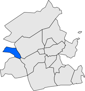
| ||||
| Géolocalisation sur la carte : Catalogne
Géolocalisation sur la carte : Espagne
Géolocalisation sur la carte : Espagne
| ||||
| modifier |
||||


Géographie
Histoire
Démographie
Économie
Lieux et Monuments
Personnalités
Jumelage
Notes et références
Annexes
Articles connexes
- Liste des comarques de Catalogne
Liens externes
 Portail de la Catalogne
На других языках
[en] Masllorenç
Masllorenç is a municipality in the comarca of the Baix Penedès in Catalonia, Spain. It is situated on the slopes of the Miramar range (864 m). A local road links the municipality with El Pla de Santa Maria, and with the A-2 autopista and the T-200 road. Masllorenç became part of the Baix Penedès in the comarcal revision of 1990: previously it formed part of the Alt Camp.[es] Maslloréns
Maslloréns[1] (oficialmente en catalán Masllorenç) es un municipio español en la comarca catalana del Bajo Panadés, Tarragona. Su población según datos de 2018 era de 498 habitantes. Se encuentra en el límite con la comarca del Alto Campo a la que perteneció antiguamente.- [fr] Masllorenç
[ru] Масльоренс
Масльоренс (кат. Masllorenç) — муниципалитет в Испании, входит в провинцию Таррагона в составе автономного сообщества Каталония. Муниципалитет находится в составе района (комарки) Баш-Пенедес. Занимает площадь 6,55 км². Население — 526 человек (на 2010 год).Текст в блоке "Читать" взят с сайта "Википедия" и доступен по лицензии Creative Commons Attribution-ShareAlike; в отдельных случаях могут действовать дополнительные условия.
Другой контент может иметь иную лицензию. Перед использованием материалов сайта WikiSort.org внимательно изучите правила лицензирования конкретных элементов наполнения сайта.
Другой контент может иметь иную лицензию. Перед использованием материалов сайта WikiSort.org внимательно изучите правила лицензирования конкретных элементов наполнения сайта.
2019-2026
WikiSort.org - проект по пересортировке и дополнению контента Википедии
WikiSort.org - проект по пересортировке и дополнению контента Википедии