world.wikisort.org - Espagne
Garcirrey est une commune de la province de Salamanque dans la communauté autonome de Castille-et-León en Espagne.
Cet article est une ébauche concernant une localité de Castille-et-León.
Vous pouvez partager vos connaissances en l’améliorant (comment ?) selon les recommandations des projets correspondants.
| Garcirrey | ||||
 Héraldique |
||||
| Administration | ||||
|---|---|---|---|---|
| Pays | ||||
| Communauté autonome | ||||
| Province | ||||
| Comarque | Campo Charro | |||
| District judic. | Salamanque | |||
| Maire Mandat |
José Maria Hernández (PP) 2015 |
|||
| Code postal | 37469 | |||
| Démographie | ||||
| Population | 58 hab. () | |||
| Densité | 0,69 hab./km2 | |||
| Géographie | ||||
| Coordonnées | 40° 54′ 03″ nord, 6° 07′ 48″ ouest | |||
| Altitude | 816 m |
|||
| Superficie | 8 425 ha = 84,25 km2 | |||
| Distance de Salamanque | 46 km | |||
| Localisation | ||||
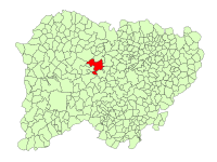 Localisation dans la province de Salamanque | ||||
| Géolocalisation sur la carte : Espagne
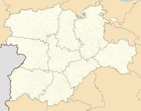
Géolocalisation sur la carte : Espagne
Géolocalisation sur la carte : Castille-et-León
| ||||
| modifier |
||||


Histoire
Garcia Rey est fondée au début du XXe siècle, en hommage à García Ier d'Oviedo (roi de 910 à 914).
Démographie
Depuis 1910 (450), la population ne cesse de diminuer.
Notes et références
Voir aussi
Articles connexes
- Campo Charro
- Liste des communes de la province de Salamanque
- Casasola de la Encomienda (es), ancienne possession de la commanderie Hospitalière de Zamayón (Langue de Castille)
Lien externe
- Pas de site de la mairie de Garcirrey ()
 Portail de Castille-et-León
На других языках
[en] Garcirrey
Garcirrey is a village and large municipality in the province of Salamanca, western Spain, part of the autonomous community of Castile-Leon. It is located 46 kilometres (29 mi) from the provincial capital city of Salamanca and has a population of 69 people.[es] Garcirrey
Garcirrey es un municipio y localidad española de la provincia de Salamanca, en la comunidad autónoma de Castilla y León. Se integra dentro de la comarca del Campo de Salamanca (Campo Charro). Pertenece al partido judicial de Salamanca.[1]- [fr] Garcirrey
[ru] Гарсиррей
Гарсиррей (исп. Garcirrey) — муниципалитет в Испании, входит в провинцию Саламанка в составе автономного сообщества Кастилия и Леон. Занимает площадь 84,25 км². Население — 86 человек (на 2010 год). Расстояние до административного центра провинции — 46 км.Текст в блоке "Читать" взят с сайта "Википедия" и доступен по лицензии Creative Commons Attribution-ShareAlike; в отдельных случаях могут действовать дополнительные условия.
Другой контент может иметь иную лицензию. Перед использованием материалов сайта WikiSort.org внимательно изучите правила лицензирования конкретных элементов наполнения сайта.
Другой контент может иметь иную лицензию. Перед использованием материалов сайта WikiSort.org внимательно изучите правила лицензирования конкретных элементов наполнения сайта.
2019-2026
WikiSort.org - проект по пересортировке и дополнению контента Википедии
WikiSort.org - проект по пересортировке и дополнению контента Википедии