world.wikisort.org - Espagne
Garafía est une commune de la province de Santa Cruz de Tenerife dans la communauté autonome des Îles Canaries en Espagne. Elle est située sur la côte nord de l'île de La Palma.
Cet article est une ébauche concernant une localité des îles Canaries.
Vous pouvez partager vos connaissances en l’améliorant (comment ?) selon les recommandations des projets correspondants.
| Garafía | |||||
 Héraldique |
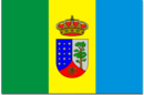 Drapeau |
||||
 Église Nuestra Señora de la Luz à Santo Domingo de Garafía. | |||||
| Administration | |||||
|---|---|---|---|---|---|
| Pays | |||||
| Communauté autonome | |||||
| Province | |||||
| Île | |||||
| Comarque | Noroeste | ||||
| District judic. | Los Llanos de Aridane | ||||
| Maire | Yeray Rodríguez Rodríguez (PSOE) | ||||
| Code postal | 38787 | ||||
| Démographie | |||||
| Gentilé | Garafiano/a | ||||
| Population | 1 813 hab. () | ||||
| Densité | 18 hab./km2 | ||||
| Géographie | |||||
| Coordonnées | 28° 38′ 00″ nord, 17° 46′ 00″ ouest | ||||
| Altitude | 365 m |
||||
| Superficie | 10 300 ha = 103 km2 | ||||
| Bordée par | Océan Atlantique | ||||
| Localisation | |||||
| Géolocalisation sur la carte : Espagne
Géolocalisation sur la carte : Îles Canaries
Géolocalisation sur la carte : Îles Canaries
Géolocalisation sur la carte : La Palma
| |||||
| Liens | |||||
| Site web | www.garafia.es | ||||
| modifier |
|||||


Géographie
Localisation
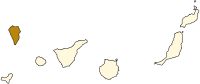
Localisation de l'île de La Palma
dans les Îles Canaries.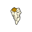
Localisation de Garafía
dans l'île de La Palma.


Villages de la commune
- Santo Domingo de Garafía (515)
- Las Tricias (310)
- Franceses (232)
- Cueva del Agua (175)
- Roque del Faro (108)
- Hoya Grande (94)
- Llano Negro (83)
- El Palmar (66)
- El Castillo (74)
- La Mata (56)
- Juan Adalid-El Mudo (52)
- El Tablado (42)
- Don Pedro (42)
Entre parenthèses figure le nombre d'habitants de chaque village en 2007[1].
Démographie
| Année | Population | Densité |
|---|---|---|
| 1991 | 2.013 | - |
| 1996 | 2.002 | - |
| 2001 | 1.795 | 17.42/km² |
| 2002 | 2.002 | - |
| 2003 | 1.998 | 19.38/km² |
| 2004 | 1.948 | 18.78/km² |
| 2005 | 1.924 | 18.68/km² |
| 2006 | 1.886 | 18.31/km² |
| 2007 | 1.849 | 17.95/km² |
| 2008 | 1.829 | 17.75/km² |
| 2009 | 1.804 | 17.51/km² |
Notes et références
Voir aussi
Articles connexes
- Liste des communes des îles Canaries
- Liste des communes de la province de Santa Cruz de Tenerife
Lien externe
 Portail des îles Canaries
На других языках
[de] Garafía
Garafía (vollständiger Name: Villa de Garafía) ist die nördlichste der 14 Gemeinden der zu Spanien gehörenden Kanareninsel La Palma. Der Verwaltungssitz ist Santo Domingo de Garafía.[en] Garafía
Garafía is a municipality in the island of La Palma, Santa Cruz de Tenerife (Canary Islands).[3] Located in the northwest of the island, in the middle od two whims of nature: the ravines of Franceses (by the North) bordering Barlovento and Izcagua by the South (born at the foot of the Roque de los Muchachos), bordering Punta Gorda . The administrative capital, home to the City Council, is called Santo Domingo and has a length of 25.50 km coastline. with cliffs of incredible beauty but very steep and difficult to access, which can only be reached on foot, demanding a great effort to those not used to walking on rough terrain. Yes, their landscapes not leave anyone indifferent by the canopy of deep green vegetation that tupe those cliffs and see the ravines in contrast to the blue of the sky and its wild seas, as an example cited the gorgeous Beach Bujarén in Santo Domingo, with its roques; is the North of La Palma: a magical, unique, and unparalleled place.[es] Garafía
Garafía es un municipio español perteneciente a la isla de La Palma, provincia de Santa Cruz de Tenerife (Islas Canarias).- [fr] Garafía
[ru] Гарафия
Гарафи́я (исп. Garafía) — муниципалитет в Испании, входит в провинцию Санта-Крус-де-Тенерифе в составе автономного сообщества Канарские острова. Находится на острове Пальма. Занимает площадь 102,99 км². Население 1714 человек (на 2010 год).Текст в блоке "Читать" взят с сайта "Википедия" и доступен по лицензии Creative Commons Attribution-ShareAlike; в отдельных случаях могут действовать дополнительные условия.
Другой контент может иметь иную лицензию. Перед использованием материалов сайта WikiSort.org внимательно изучите правила лицензирования конкретных элементов наполнения сайта.
Другой контент может иметь иную лицензию. Перед использованием материалов сайта WikiSort.org внимательно изучите правила лицензирования конкретных элементов наполнения сайта.
2019-2026
WikiSort.org - проект по пересортировке и дополнению контента Википедии
WikiSort.org - проект по пересортировке и дополнению контента Википедии