world.wikisort.org - Sudafrica
Danabaai è un centro abitato sudafricano situato nella municipalità distrettuale di Eden nella provincia del Capo Occidentale. La località è affacciata sull'oceano Indiano e si trova a est della città di Mosselbaai.
| Danabaai città | |
|---|---|
| Localizzazione | |
| Stato | |
| Provincia | Capo Occidentale |
| Distretto | Eden |
| Municipalità locale | Mossel Bay |
| Territorio | |
| Coordinate | 34°11′57.12″S 22°02′30.12″E |
| Superficie | 9,66[1] km² |
| Abitanti | 2 590[2] (2011) |
| Densità | 268,12 ab./km² |
| Altre informazioni | |
| Cod. postale | 6510 |
| Fuso orario | UTC+2 |
| Cartografia | |
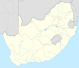 Danabaai | |
L'area è ricoperta dal fynbos, di cui ospita numerose specie endemiche, ed è pertanto protetta.
Note
| Controllo di autorità | VIAF (EN) 129179754 · LCCN (EN) n97100597 |
|---|
На других языках
[en] Danabaai
Dana Bay can really be considered as a sort of village with a mini supermarket, bakery, butchery, eating establishments, fuel station and liquor outlets amongst other small businesses and forms part of the greater Mossel Bay municipality. The village forms the west boundary of the Garden Route District, Western Cape, South Africa. Dana Bay lies approximately halfway between Port Elizabeth and Cape Town and is a mere 4 kilometers off the N2 highway. The central part of Mossel Bay is about 12 kilometers from Dana Bay.- [it] Danabaai
Текст в блоке "Читать" взят с сайта "Википедия" и доступен по лицензии Creative Commons Attribution-ShareAlike; в отдельных случаях могут действовать дополнительные условия.
Другой контент может иметь иную лицензию. Перед использованием материалов сайта WikiSort.org внимательно изучите правила лицензирования конкретных элементов наполнения сайта.
Другой контент может иметь иную лицензию. Перед использованием материалов сайта WikiSort.org внимательно изучите правила лицензирования конкретных элементов наполнения сайта.
2019-2025
WikiSort.org - проект по пересортировке и дополнению контента Википедии
WikiSort.org - проект по пересортировке и дополнению контента Википедии