world.wikisort.org - South_Africa
Mapela is a large village located northwest of the town of Mokopane in the Waterberg district of the Limpopo province in South Africa.
This article relies largely or entirely on a single source. (April 2017) |
Mapela | |
|---|---|
 Mapela  Mapela | |
| Coordinates: 24.021°S 28.853°E | |
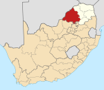
| Country | South Africa |
| Province | Limpopo |
| District | Waterberg |
| Municipality | Mogalakwena |
| Area | |
| • Total | 4.62 km2 (1.78 sq mi) |
| Population (2011)[1] | |
| • Total | 3,549 |
| • Density | 770/km2 (2,000/sq mi) |
| Racial makeup (2011) | |
| • Black African | 99.8% |
| • Indian/Asian | 0.1% |
| • Other | 0.1% |
| First languages (2011) | |
| • Northern Sotho | 95.3% |
| • Tsonga | 1.4% |
| • Other | 3.4% |
| Time zone | UTC+2 (SAST) |
| Postal code (street) | 0610 |
| PO box | 0610 |
References
- "Main Place Mapela". Census 2011.
Municipalities and communities of Waterberg District Municipality, Limpopo | ||
|---|---|---|
District seat: Nylstroom (Modimolle) | ||
| Thabazimbi |
|  |
| Lephalale |
| |
| Modimolle–Mookgophong |
| |
| Bela-Bela |
| |
| Mogalakwena |
| |
Authority control | |
|---|---|
| General |
|
| National libraries | |
This Limpopo location article is a stub. You can help Wikipedia by expanding it. |
Текст в блоке "Читать" взят с сайта "Википедия" и доступен по лицензии Creative Commons Attribution-ShareAlike; в отдельных случаях могут действовать дополнительные условия.
Другой контент может иметь иную лицензию. Перед использованием материалов сайта WikiSort.org внимательно изучите правила лицензирования конкретных элементов наполнения сайта.
Другой контент может иметь иную лицензию. Перед использованием материалов сайта WikiSort.org внимательно изучите правила лицензирования конкретных элементов наполнения сайта.
2019-2025
WikiSort.org - проект по пересортировке и дополнению контента Википедии
WikiSort.org - проект по пересортировке и дополнению контента Википедии