world.wikisort.org - Slovaquie
Dohňany (hongrois : Donány)[4] est un village de Slovaquie situé dans la région de Trenčín.
| Dohňany | |||||
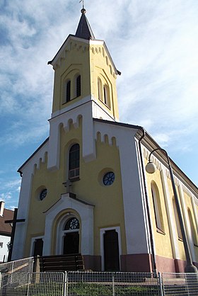
 Église Saint-Cyrille-Saint-Méthode | |||||
| Administration | |||||
|---|---|---|---|---|---|
| Pays | |||||
| Région | Trenčín | ||||
| District | Púchov | ||||
| Statut | Village | ||||
| Starosta (maire) Mandat |
Milan Panáček (SMER-SD) mandat : 2018-2022 |
||||
| Code postal | 020 51 | ||||
| Plaque minéralogique |
PU | ||||
| Code LAU 2 | 512940 | ||||
| Démographie | |||||
| Population | 1 815 hab. (31 déc. 2018) | ||||
| Densité | 63 hab./km2 | ||||
| Géographie | |||||
| Coordonnées | 49° 08′ 44″ nord, 18° 17′ 28″ est | ||||
| Altitude | 336 m |
||||
| Superficie | 2 875,211 8 ha = 28,752 118 km2 | ||||
| Localisation | |||||
| Géolocalisation sur la carte : Slovaquie
Géolocalisation sur la carte : Slovaquie
Géolocalisation sur la carte : région de Trenčín
Géolocalisation sur la carte : région de Trenčín
| |||||
| Liens | |||||
| Site web | https://www.dohnany.sk | ||||
| Sources | |||||
| « Résultat des élections » | |||||
| « Statistique de population » | |||||
| https://www.e-obce.sk [1] | |||||
| http://www.statistics.sk [2] http://www.slovakregion.sk/ [3] |
|||||
| modifier |
|||||
Histoire
La première mention écrite du village date de 1471[2].
Notes et références
- « (sk) e-obce.sk » (consulté le )
- « (sk) (en) Mestská a obecná štatistika SR » (consulté le )
- « (sk) Slovak region » (consulté le )
- « (sk) Slovenské slovníky » (consulté le )
Voir aussi
- Portail de la Slovaquie
На других языках
[de] Dohňany
Dohňany (bis 1927 slowakisch auch Dohnany; ungarisch Donány oder älter Dohnan) ist ein Ort und eine Gemeinde im Nordwesten der Slowakei, mit 1858 Einwohnern (Stand 31. Dezember 2020). Er gehört zum Okres Púchov innerhalb der höheren Verwaltungseinheit Trenčiansky kraj.[en] Dohňany
Dohňany (Hungarian: Donány) is a village and municipality in Púchov District in the Trenčín Region of north-western Slovakia.- [fr] Dohňany
Текст в блоке "Читать" взят с сайта "Википедия" и доступен по лицензии Creative Commons Attribution-ShareAlike; в отдельных случаях могут действовать дополнительные условия.
Другой контент может иметь иную лицензию. Перед использованием материалов сайта WikiSort.org внимательно изучите правила лицензирования конкретных элементов наполнения сайта.
Другой контент может иметь иную лицензию. Перед использованием материалов сайта WikiSort.org внимательно изучите правила лицензирования конкретных элементов наполнения сайта.
2019-2025
WikiSort.org - проект по пересортировке и дополнению контента Википедии
WikiSort.org - проект по пересортировке и дополнению контента Википедии


