world.wikisort.org - Slovakia
Topoľa (Rusyn: Тополя, Hungarian: Kistopolya) is a village and municipality in Snina District in the Prešov Region of north-eastern Slovakia.
Topoľa | |
|---|---|
Municipality | |
 Wooden church of Saint Michael | |
 Topoľa Location of Topoľa in the Prešov Region  Topoľa Location of Topoľa in Slovakia | |
| Coordinates: 49°03′N 22°22′E | |
| Country | |
| Region | Prešov |
| District | Snina |
| First mentioned | 1337 |
| Area | |
| • Total | 26.38[1] km2 (10.19[1] sq mi) |
| Elevation | 381[2] m (1,250[2] ft) |
| Population (2021) | |
| • Total | 164[3] |
| Time zone | UTC+1 (CET) |
| • Summer (DST) | UTC+2 (CEST) |
| Postal code | 067 65[2] |
| Area code | +421 57[2] |
| Car plate | SV |
| Website | topola |
Geography
The municipality is located in Snina District in the Prešov Region of north-eastern Slovakia. It lies at an altitude of 384 metres and covers an area of 26.384 km². According to the 2013 census, it had a population of 159 inhabitants.
History
In historical records the village was first mentioned in 1337. The Greek Catholic wooden church of Archangel Michael located on the hill above the village dates back as far as 1700. There is a cemetery of soldiers who fell in World War I adjacent to the church. The name of the village is derived from topoľ, the poplar tree.
Protected areas and natural landmarks
The municipality is situated in the buffer zone of the Poloniny National Park. It offers easy access to most of the National Park's hiking trails. Havešová, a component of the Primeval Beech Forests of the Carpathians UNESCO World Heritage Site, is also located close to the village.
Gallery
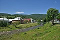 Main street in Topoľa, the Ulička stream at the centre
 Street in Topoľa and access road to the Church of Saint Michael and communal cemetery
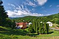 View of the village from the wooden church
 Wooden church of Saint Michael in Topoľa
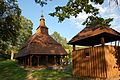 Wooden church of Saint Michael and wooden belfry in Topoľa
 Wooden church of Saint Michael in Topoľa
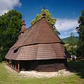 Wooden church of Saint Michael in Topoľa
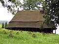 Wooden church of Saint Michael in Topoľa
 Jewish cemetery in Topoľa
 First world war military cemetery
 First world war military cemetery
 First world war military cemetery
 Modern church of Saint Peter and Paul in Topoľa
 View from the end of Havešová towards the village of Topoľa (upper left)


See also
- Bukovské vrchy
- Stužica
- Poloniny National Park
References
- "Hustota obyvateľstva - obce [om7014rr_ukaz: Rozloha (Štvorcový meter)]". www.statistics.sk (in Slovak). Statistical Office of the Slovak Republic. 2022-03-31. Retrieved 2022-03-31.
- "Základná charakteristika". www.statistics.sk (in Slovak). Statistical Office of the Slovak Republic. 2015-04-17. Retrieved 2022-03-31.
- "Počet obyvateľov podľa pohlavia - obce (ročne)". www.statistics.sk (in Slovak). Statistical Office of the Slovak Republic. 2022-03-31. Retrieved 2022-03-31.
External links
 Media related to Topoľa at Wikimedia Commons
- Official website

- Village of Topoľa
- Wooden Churches in Slovakia
This Prešov Region geography article is a stub. You can help Wikipedia by expanding it. |
На других языках
[de] Topoľa
Topoľa (ungarisch Kistopolya – bis 1907 Topolya, russinisch Тополя/Topolja) ist eine kleine Gemeinde im Okres Snina (Prešovský kraj) im äußersten Osten der Slowakei, mit 145 Einwohnern (Stand 31. Dezember 2020). Gemäß der Volkszählung 2001 (226 Einw.) lebten neben Slowaken (45,13 %) auch bedeutende russinische (41,59 %) und ukrainische (4,42 %) Minderheiten in Topoľa.- [en] Topoľa
[ru] Тополя (Снина)
Тополя (словацк. Topoľa) — село в Словакии, Снинского района, Прешовского края. Расположено на северо-востоке Словакии недалеко от границы с Польшей.Другой контент может иметь иную лицензию. Перед использованием материалов сайта WikiSort.org внимательно изучите правила лицензирования конкретных элементов наполнения сайта.
WikiSort.org - проект по пересортировке и дополнению контента Википедии