world.wikisort.org - Serbien
Neštin ist ein Dorf mit etwa 800 Einwohnern in der Opština Bačka Palanka, Serbien. Es liegt an der Grenze zu Kroatien und ist eine Quasi-Exklave. Im Westen grenzt das Dorf ans kroatische Ilok an; an der Grenze beginnt die Magistrale 119 die nach Sremska Kamenica führt.
| Volkszählung | 1948 | 1953 | 1961 | 1971 | 1981 | 1991 | 2002 | 2011 |
|---|---|---|---|---|---|---|---|---|
| Einwohner | 1120 | 1163 | 1217 | 1088 | 1043 | 1002 | 900 | 794 |
| Нештин Neštin | ||||
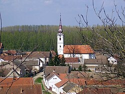
 Blick auf die Dorfkirche | ||||
| ||||
| Basisdaten | ||||
|---|---|---|---|---|
| Staat: | ||||
| Provinz: | Vojvodina | |||
| Okrug: | Južna Bačka | |||
| Opština: | Bačka Palanka | |||
| Koordinaten: | 45° 14′ N, 19° 27′ O | |||
| Höhe: | 135 m. i. J. | |||
| Fläche: | 33,8 km² | |||
| Einwohner: | 794 (2011) | |||
| Bevölkerungsdichte: | 23 Einwohner je km² | |||
| Telefonvorwahl: | (+381) 21 | |||
| Postleitzahl: | 21314 | |||
| Kfz-Kennzeichen: | NS | |||
| Struktur und Verwaltung | ||||
| Gemeindeart: | Dorf | |||
Einzelnachweise
- Serbian censuses. In: pop-stat.mashke.org. Abgerufen am 7. Juni 2021.
На других языках
- [de] Neštin
[en] Neštin
Neštin (Serbian Cyrillic: Нештин) is a village located in the Bačka Palanka municipality, in the South Bačka District of the autonomous province of Vojvodina, Serbia. Geographically, it is located the region of Syrmia. According to the 2011 census, the village has a population of 794 inhabitants.[1] Also, vine produced in Neštin is famous.Текст в блоке "Читать" взят с сайта "Википедия" и доступен по лицензии Creative Commons Attribution-ShareAlike; в отдельных случаях могут действовать дополнительные условия.
Другой контент может иметь иную лицензию. Перед использованием материалов сайта WikiSort.org внимательно изучите правила лицензирования конкретных элементов наполнения сайта.
Другой контент может иметь иную лицензию. Перед использованием материалов сайта WikiSort.org внимательно изучите правила лицензирования конкретных элементов наполнения сайта.
2019-2025
WikiSort.org - проект по пересортировке и дополнению контента Википедии
WikiSort.org - проект по пересортировке и дополнению контента Википедии

