world.wikisort.org - Russia
Lorino (Russian: Лорино; Chukchi: Ԓьурэн, Ḷ'urèn, lit. found camp;[9] Naukan: Lluughraq) is a rural locality (a selo) in Chukotsky District of Chukotka Autonomous Okrug, Russia.[1] It is located on the boundary of the Chukchi Sea and the Bering Sea. Population: 1,267 (2010 Census);[2] [3] Municipally, Lorino is subordinated to Chukotsky Municipal District and incorporated as Lorino Rural Settlement.[5]
Lorino
Лорино | |
|---|---|
Selo[1] | |
 A typical family home in Lorino | |
Location of Lorino  | |
 Lorino Location of Lorino  Lorino Lorino (Chukotka Autonomous Okrug) | |
| Coordinates: 65°30′15″N 171°42′15″W | |
| Country | Russia |
| Federal subject | Chukotka Autonomous Okrug[1] |
| Administrative district | Chukotsky District |
| Population | |
| • Total | 1,267 |
| • Estimate (January 2018)[4] | 998 |
Municipal status | |
| • Municipal district | Chukotsky Municipal District[5] |
| • Rural settlement | Lorino Rural Settlement[5] |
| • Capital of | Lorino Rural Settlement[5] |
| Time zone | UTC+12 (MSK+9 |
| Postal code(s)[7] | 689315 |
| Dialing code(s) | +7 42736[8] |
| OKTMO ID | 77633423101 |
Geography
Lorino is the largest indigenous village in the whole autonomous okrug and larger even than Lavrentiya, the administrative centre of the district, which is found to the north-west. The village is located on the shores of the Bering Sea, on the Mechigmen spit. it is 40.5 km to the district centre.[10] Near the village are the Lorinski (Kukunyskie) hot springs.[10]
History
The name "Lorino" comes from the Chukchi "льурэн" (lyuren), meaning "found camp".[9][11] The first mention of Lorino comes from the 18th century,[12] with the modern Chukchi village located on the site of the former Eskimo settlement of Nukak [6].[13] The main occupations of the inhabitants are sea mammal hunting, reindeer herding and fishing and the village is the base for the municipal agricultural enterprise "Keper" (Russian: Кэпэр).[13] A fox farm was established in the village in 1955 and a processing factory for seafood and meat canning was opened in 2009.[14]
Culture
The area around the village was used as the setting for the film The Chief of Chukotka.[15] The Lorino hot springs are located 15 kilometers (9.3 mi) from the village.[15]
The village has a high school, a daycare center, a boarding school, a cultural center, a food store, a hospital, a post-office, and a breeding farm with more than 300 Arctic foxes.[15] The Lorino Dawns native ensemble under the guidance of N. Ginuntegin is based in the village.[15]
Demographics
The population as of the official 2010 census results was 1267,[2] of whom 628 were male and 639 female.[3] This is a reduction on a 2003 estimate by Red Cross Chukotka as 1,419,[15] of which 1,288 were indigenous peoples.[15]
Transport
The village of Lorino is linked to Lavrentiya by a 40 kilometers (25 mi) unpaved road. There is, however, a small number of roads within the settlement including:[16]
- Улица Гагарина (Ulitsa Gagarina, lit. Gagarin Street)
- Улица Енок (Ulitsa Yenok)
- Улица Ленина (Ulitsa Lenina, lit. Lenin Street)
- Улица Челюскинцев (Ulitsa Chelyuskintsev, lit Chelyuskin Street)
- Улица Чукотская (Ulitsa Chukotskaya, lit. Chukotka Street)
Climate
Lorino has a Tundra climate (ET)[17] because the warmest month has an average temperature between 0 °C (32 °F) and 10 °C (50 °F).
| Climate data for Lorino | |||||||||||||
|---|---|---|---|---|---|---|---|---|---|---|---|---|---|
| Month | Jan | Feb | Mar | Apr | May | Jun | Jul | Aug | Sep | Oct | Nov | Dec | Year |
| Record high °C (°F) | 4.7 (40.5) |
5.5 (41.9) |
3.9 (39.0) |
6.4 (43.5) |
10.5 (50.9) |
18.4 (65.1) |
22.7 (72.9) |
22.0 (71.6) |
16.3 (61.3) |
12.0 (53.6) |
8.7 (47.7) |
10.0 (50.0) |
22.7 (72.9) |
| Average high °C (°F) | −17.9 (−0.2) |
−16.7 (1.9) |
−15.8 (3.6) |
−9.1 (15.6) |
−0.7 (30.7) |
5.6 (42.1) |
10.0 (50.0) |
9.2 (48.6) |
5.4 (41.7) |
0.5 (32.9) |
−4.7 (23.5) |
−13.9 (7.0) |
−4.0 (24.8) |
| Average low °C (°F) | −23.9 (−11.0) |
−22.8 (−9.0) |
−22.3 (−8.1) |
−15.2 (4.6) |
−4.6 (23.7) |
1.0 (33.8) |
4.8 (40.6) |
4.8 (40.6) |
2.2 (36.0) |
−3.0 (26.6) |
−9.8 (14.4) |
−19.0 (−2.2) |
−9.0 (15.8) |
| Record low °C (°F) | −44.1 (−47.4) |
−41.5 (−42.7) |
−41.4 (−42.5) |
−31.1 (−24.0) |
−24.5 (−12.1) |
−5.6 (21.9) |
−4.7 (23.5) |
−2.7 (27.1) |
−6.1 (21.0) |
−19.9 (−3.8) |
−33.6 (−28.5) |
−41.2 (−42.2) |
−44.1 (−47.4) |
| Average rainfall mm (inches) | 19.0 (0.75) |
20.0 (0.79) |
13.8 (0.54) |
18.1 (0.71) |
18.8 (0.74) |
15.1 (0.59) |
40.4 (1.59) |
46.2 (1.82) |
35.9 (1.41) |
45.4 (1.79) |
28.8 (1.13) |
18.4 (0.72) |
319.9 (12.59) |
| Average snowy days | 14 | 12 | 11 | 15 | 13 | 3 | 0 | 0 | 4 | 17 | 20 | 15 | 124 |
| Source: [18] | |||||||||||||
Gallery
 Lorino (Bering Sea, Russia, 65°30’N, 171°42’W)
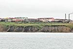 Lorino
 Soviet era apartments
in Lorino Soviet era guard tower
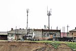 Lorino,
Telecommunication station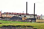 Lorino,
Power station Lorino,
former fox farm Fox farm (details)
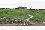 Lorino,
boat landing pad with road to community center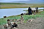 Lorino,
sled dogs teams at the beach Female dancers
 Boy in traditional costume


See also
References
Notes
- Law #33-OZ, Article 13.2
- Russian Federal State Statistics Service (2011). Всероссийская перепись населения 2010 года. Том 1 [2010 All-Russian Population Census, vol. 1]. Всероссийская перепись населения 2010 года [2010 All-Russia Population Census] (in Russian). Federal State Statistics Service.
- The results of the 2010 Census are given for Lorino Rural Settlement, a municipal formation of Chukotsky Municipal District. According to Law #148-OZ, Lorino is the only inhabited locality on the territory of Lorino Rural Settlement.
- Office of the Federal State Statistics Service for Khabarovsk Krai, Magadan Oblast, Jewish Autonomous Oblast and Chukotka Autonomous Okrug. Численность населения Чукотского автономного округа по муниципальным образованиям на 1 января 2018 года Archived 2019-08-31 at the Wayback Machine (in Russian)
- Law #47-OZ, Article 3
- "Об исчислении времени". Официальный интернет-портал правовой информации (in Russian). 3 June 2011. Retrieved 19 January 2019.
- Почта России. Информационно-вычислительный центр ОАСУ РПО. (Russian Post). Поиск объектов почтовой связи (Postal Objects Search) (in Russian)
- Ministry of Justice of the Russian Federation Archived 2012-02-08 at the Wayback Machine Chukotsky District (in Russian)
- V.V. Leontev and K.A. Novikova, Топонимический словарь северо-востока СССР (Toponymic Dictionary of the Northeastern USSR) (1989) Magadan. p.329
- Село Лорино Archived 2011-06-20 at WebCite (Lorino Village) Chukotka Electoral Commission Website
- Strogoff, p. 114
- Традиционный праздник села отметили жители Лорино Archived 2014-07-14 at the Wayback Machine (Traditional holiday village residents noted Lorino) chukotnews.ru
- "Beringia Park - Lorino". Ethnic and Natural Park Beringia. Archived from the original on 2013-08-16. Retrieved 2011-06-21.
- "Поселения Чукотского района (Settlements in Chukotsky District)". Официальный сайт Чукотского муниципального района (Chukotsky District Official Website). Archived from the original on 2010-07-25. Retrieved 2011-06-21.
- Red Cross of Chukotka. Chukotsky District (Archived)
- Lorino - Chukotsky District Pochtovik Mail Delivery Service (in Russian)
- McKnight and Hess, pp.235-7
- "Weather Averages for Lorinofrom meoweather.com". meoweather.com. Retrieved October 2, 2012.
Sources
- McKnight, Tom L; Hess, Darrel (2000). "Climate Zones and Types". Physical Geography: A Landscape Appreciation. Upper Saddle River, NJ: Prentice Hall. ISBN 0-13-020263-0.
- Дума Чукотского автономного округа. Закон №33-ОЗ от 30 июня 1998 г. «Об административно-территориальном устройстве Чукотского автономного округа», в ред. Закона №55-ОЗ от 9 июня 2012 г. «О внесении изменений в Закон Чукотского автономного округа "Об административно-территориальном устройстве Чукотского автономного округа"». Вступил в силу по истечении десяти дней со дня его официального опубликования. Опубликован: "Ведомости", №7 (28), 14 мая 1999 г. (Duma of Chukotka Autonomous Okrug. Law #33-OZ of June 30, 1998 On the Administrative-Territorial Structure of Chukotka Autonomous Okrug, as amended by the Law #55-OZ of June 9, 2012 On Amending the Law of Chukotka Autonomous Okrug "On the Administrative-Territorial Structure of Chukotka Autonomous Okrug". Effective as of after ten days from the day of the official publication.). (in Russian)
- Дума Чукотского автономного округа. Закон №47-ОЗ от 29 ноября 2004 г. «О статусе, границах и административных центрах муниципальных образований на территории Чукотского района Чукотского автономного округа». Вступил в силу через десять дней со дня официального опубликования. Опубликован: "Ведомости", №31/1 (178/1), 10 декабря 2004 г. (Duma of Chukotka Autonomous Okrug. Law #47-OZ of November 29, 2004 On the Status, Borders, and Administrative Centers of the Municipal Formations on the Territory of Chukotsky District of Chukotka Autonomous Okrug. Effective as of the day which is ten days after the official publication date.). (in Russian)
- Strogoff, M, Brochet, P-C and Auzias, D. Petit Futé: Chukotka, "Avant-Garde" Publishing House, 2006.
На других языках
[de] Lorino (Tschukotka)
Lorino (russisch Лорино; tschuktschisch Льурэн; Yupik Нукак) ist ein Dorf mit 1267 Einwohnern (Stand 14. Oktober 2010)[1] im nordöstlichen Teil des Autonomen Kreises der Tschuktschen im äußersten Osten Russlands.- [en] Lorino, Chukotka Autonomous Okrug
[ru] Лорино (Чукотский автономный округ)
Ло́рино (чук. Ԓьурэн, чапл. Нуӄаӄ, наукан. Лъуӷраӄ[1]) — село в Чукотском районе Чукотского автономного округа[3]. Образует сельское поселение Лорино. Крупнейшее национальное село на Чукотском полуострове.Другой контент может иметь иную лицензию. Перед использованием материалов сайта WikiSort.org внимательно изучите правила лицензирования конкретных элементов наполнения сайта.
WikiSort.org - проект по пересортировке и дополнению контента Википедии