world.wikisort.org - Russia
Kumachyovo or Kumachevo (Russian: Кумачёво; German: Kumehnen; Lithuanian: Kumėnai) is a rural settlement in Zelenogradsky District, Kaliningrad Oblast, Russia, part of the Pereslavskoye rural municipality.[4] It is located on the Sambian Peninsula.
This article may be expanded with text translated from the corresponding article in German. (June 2016) Click [show] for important translation instructions.
|
Kumachyovo
Кумачёво | |
|---|---|
Rural locality | |
 Medieval church ruins | |
Location of Kumachyovo  | |
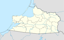 Kumachyovo Location of Kumachyovo 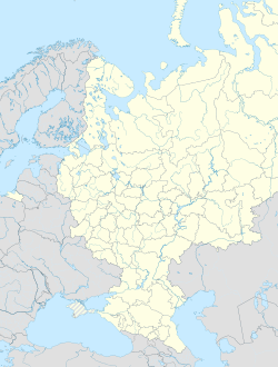 Kumachyovo Kumachyovo (European Russia)  Kumachyovo Kumachyovo (Russia) | |
| Coordinates: 54.821°N 20.214°E | |
| Country | Russia |
| Federal subject | Kaliningrad Oblast |
| Administrative district | Zelenogradsky District |
| Elevation | 71 m (233 ft) |
| Population | |
| • Total | 541 |
| Time zone | UTC+2 (MSK–1 |
| Postal code(s)[3] | 238542 |
| OKTMO ID | 27710000611 |
History
The local Gothic church was built in 1390.[5] In 1454, King Casimir IV Jagiellon incorporated the region to the Kingdom of Poland upon the request of the anti-Teutonic Prussian Confederation.[6] After the subsequent Thirteen Years' War (1454–1466), it became a part of Poland as a fief held by the Teutonic Knights until 1525,[7] and by Ducal Prussia afterwards.
From the 18th century it formed part of the Kingdom of Prussia, and from 1871 it was also part of the German Empire, within which it was located in the province of East Prussia. After Germany's defeat in World War II, in 1945, it passed to the Soviet Union. In the post-war period, the abandoned church gradually deteriorated.[5]
References
- Russian Federal State Statistics Service (2011). Всероссийская перепись населения 2010 года. Том 1 [2010 All-Russian Population Census, vol. 1]. Всероссийская перепись населения 2010 года [2010 All-Russia Population Census] (in Russian). Federal State Statistics Service.
- "Об исчислении времени". Официальный интернет-портал правовой информации (in Russian). 3 June 2011. Retrieved 19 January 2019.
- Почта России. Информационно-вычислительный центр ОАСУ РПО. (Russian Post). Поиск объектов почтовой связи (Postal Objects Search) (in Russian)
- "Генеральный план МО «Переславское сельское поселение»". Archived from the original on 2016-04-04. Retrieved 2016-06-08.
- "Die Kirchen im Samland / Genealogy East Prussia (Sambia)".
- Górski, Karol (1949). Związek Pruski i poddanie się Prus Polsce: zbiór tekstów źródłowych (in Polish). Poznań: Instytut Zachodni. p. 54.
- Górski, pp. 96–97, 214–215
This Russian location article is a stub. You can help Wikipedia by expanding it. |
На других языках
- [en] Kumachyovo
[ru] Кумачёво (Зеленоградский район)
Кумачёво (до 1946 года — Куменен, нем. Kumehnen) — посёлок Зеленоградского района Калининградской области. Входит в состав Переславского сельского поселения. Население 582 человека (2010)[2].Другой контент может иметь иную лицензию. Перед использованием материалов сайта WikiSort.org внимательно изучите правила лицензирования конкретных элементов наполнения сайта.
WikiSort.org - проект по пересортировке и дополнению контента Википедии