world.wikisort.org - Portugal
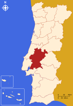
The District of Santarém (Portuguese: Distrito de Santarém [sɐ̃tɐˈɾɐ̃j̃] (![]() listen)) is a district of Portugal, located in Portugal's Centro Region. The district capital is the city of Santarém.
listen)) is a district of Portugal, located in Portugal's Centro Region. The district capital is the city of Santarém.
District of Santarém | |
|---|---|
District | |
 Coat of arms | |
 | |
| Country | Portugal |
| Region | Centro and Alentejo |
| Historical province | Ribatejo (partly Beira Baixa and Beira Litoral) |
| No. of municipalities | 21 |
| No. of parishes | 193 |
| Capital | Santarém |
| Area | |
| • Total | 6,747 km2 (2,605 sq mi) |
| Population | |
| • Total | 475,344 |
| • Density | 70/km2 (180/sq mi) |
| ISO 3166 code | PT-14 |
| No. of parliamentary representatives | 9 |
The district is the 3rd largest in Portugal, with an area of 6,747 km2 (2,605 sq mi), and a population of 475,344 inhabitants, giving it a population density of 70 people per sq. kilometer (180 people per sq. mile).
Once part of the historical region of Ribatejo, the district was created by order of the European Union, not taking into consideration historical boundaries or cultures.
Municipalities
The district includes the following 21 municipalities.
- Abrantes
- Alcanena
- Almeirim
- Alpiarça
- Benavente
- Cartaxo
- Chamusca
- Constância
- Coruche
- Entroncamento
- Ferreira do Zêzere
- Golegã
- Mação
- Ourém
- Rio Maior
- Salvaterra de Magos
- Santarém
- Sardoal
- Tomar
- Torres Novas
- Vila Nova da Barquinha
Summary of votes and seats won 1976-2022
| Parties | % | S | % | S | % | S | % | S | % | S | % | S | % | S | % | S | % | S | % | S | % | S | % | S | % | S | % | S | % | S | % | S |
|---|---|---|---|---|---|---|---|---|---|---|---|---|---|---|---|---|---|---|---|---|---|---|---|---|---|---|---|---|---|---|---|---|
| 1976 | 1979 | 1980 | 1983 | 1985 | 1987 | 1991 | 1995 | 1999 | 2002 | 2005 | 2009 | 2011 | 2015 | 2019 | 2022 | |||||||||||||||||
| PS | 38.4 | 6 | 27.3 | 3 | 30.4 | 4 | 38.4 | 5 | 18.6 | 2 | 21.7 | 3 | 29.4 | 3 | 45.8 | 5 | 45.5 | 5 | 38.4 | 4 | 46.1 | 6 | 33.7 | 4 | 25.9 | 3 | 32.9 | 3 | 37.1 | 4 | 41.2 | 5 |
| PSD | 19.5 | 3 | In AD | 24.7 | 3 | 27.8 | 4 | 47.9 | 7 | 49.1 | 6 | 31.0 | 3 | 30.2 | 3 | 38.1 | 4 | 26.4 | 3 | 27.0 | 3 | 37.6 | 5 | In PàF | 25.2 | 3 | 26.9 | 3 | ||||
| CDS-PP | 13.9 | 2 | 10.0 | 1 | 7.7 | 1 | 3.6 | 3.3 | 8.7 | 1 | 8.1 | 1 | 8.4 | 1 | 6.9 | 11.2 | 1 | 12.3 | 1 | 4.7 | 1.9 | |||||||||||
| PCP/APU/CDU | 16.1 | 2 | 21.7 | 3 | 19.0 | 2 | 20.0 | 3 | 16.4 | 2 | 12.6 | 1 | 9.8 | 1 | 9.5 | 1 | 10.1 | 1 | 8.6 | 1 | 8.6 | 1 | 9.2 | 1 | 9.0 | 1 | 9.6 | 1 | 7.6 | 1 | 5.4 | |
| AD | 41.0 | 6 | 42.1 | 6 | ||||||||||||||||||||||||||||
| PRD | 23.8 | 3 | 7.3 | 1 | 1.0 | |||||||||||||||||||||||||||
| BE | 2.0 | 2.8 | 6.5 | 11.8 | 1 | 5.8 | 10.8 | 1 | 10.2 | 1 | 4.6 | |||||||||||||||||||||
| PàF | 35.8 | 4 | ||||||||||||||||||||||||||||||
| CHEGA | 2.0 | 10.9 | 1 | |||||||||||||||||||||||||||||
| Total seats | 13 | 12 | 10 | 9 | ||||||||||||||||||||||||||||
| Source: Comissão Nacional de Eleições | ||||||||||||||||||||||||||||||||
Archeology
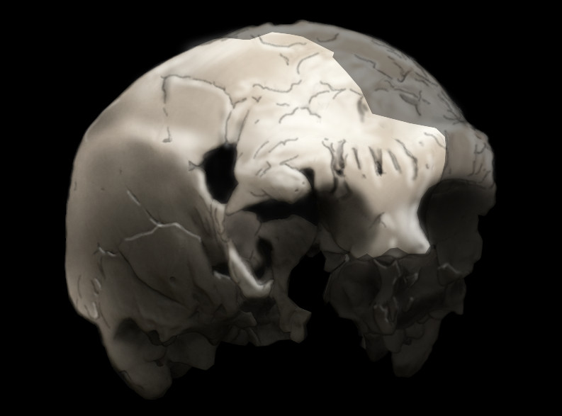
The oldest trace of human history in Portugal.
The village of Almonda, within the civil parish of Zibreira, is noted for the Aroeira cave, where the 400,000 year old Aroeira 3 skull of a Homo Heidelbergensis was discovered in 2014. It is the oldest trace of human habitation in Portugal.[1][2][3][4]
See also
- Arripiado, a village in the district of Santarém
- 1909 Benavente earthquake, a deadly seismic event centered in the district
References
- Phys Org, March 13, 2017, 400,000-year-old fossil human cranium is oldest ever found in Portugal
- Joan Daura et al.: New Middle Pleistocene hominin cranium from Gruta da Aroeira (Portugal). In: Proceedings of the National Academy of Sciences (PNAS) Online pre-release of 13 March 2017.
- The primitive man from Portugal, Article from 16 March 2017 des Hamburger Abendblatt, accessed on March 22, 2017
- Crânio de 400 mil anos é o fóssil humano mais antigo descoberto em Portugal 400,000 year old skull found the oldest human fossil in Portugal, Article from 13. March 2017 he Portuguese newspaper Público, accessed on March 22, 2017
Districts and Autonomous Regions of Portugal | ||
|---|---|---|
| Districts |
| |
| Autonomous Regions | ||
Authority control | |
|---|---|
| General | |
| National libraries | |
| Other | |
На других языках
- [en] Santarém District
[ru] Сантарен (округ)
Округ Сантарен (порт. Distrito de Santarém) — округ в центральной Португалии. Округ состоит из 21 муниципалитетов. Распределён между 3 статистическими регионами: регион Алентежу, регион Рибатежу, Центральный регион. Распределён между 3 статистическими субрегионами: Лезирия-ду-Тежу, Медиу-Тежу, Пиньял-Интериор-Сул. Ранее входил в состав провинции Рибатежу. Территория — 6723 км². Население — 453 638 человек (2011). Плотность населения — 67,48 чел./км². Административный центр — город Сантарен.Другой контент может иметь иную лицензию. Перед использованием материалов сайта WikiSort.org внимательно изучите правила лицензирования конкретных элементов наполнения сайта.
WikiSort.org - проект по пересортировке и дополнению контента Википедии