 Mourão Castle
 Street in Mourão
 View of the Alqueva Dam from the castle
world.wikisort.org - Portugal
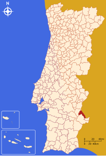
Mourão (Portuguese pronunciation: [mowˈɾɐ̃w] (![]() listen)) is a municipality in the District of Évora in Portugal. The population in 2011 was 2,663,[1] in an area of 278.63 km2.[2]
listen)) is a municipality in the District of Évora in Portugal. The population in 2011 was 2,663,[1] in an area of 278.63 km2.[2]
Mourão | |
|---|---|
Municipality | |
 | |
 Flag  Coat of arms | |
 | |
| Coordinates: 38°20′N 7°22′W | |
| Country | |
| Region | Alentejo |
| Intermunic. comm. | Alentejo Central |
| District | Évora |
| Parishes | 3 |
| Government | |
| • President | Maria Clara Safara (PS) |
| Area | |
| • Total | 278.63 km2 (107.58 sq mi) |
| Population (2011) | |
| • Total | 2,663 |
| • Density | 9.6/km2 (25/sq mi) |
| Time zone | UTC±00:00 (WET) |
| • Summer (DST) | UTC+01:00 (WEST) |
| Local holiday | February 2 |
| Website | http://www.cm-mourao.pt |
Geography
The municipality borders the municipality of Alandroal to the north, Spain to the east, Barrancos to the south-east, Moura to the south and Reguengos de Monsaraz to the east.
The town has the well-preserved Castle of Mourão.
Gallery


Politics
The present Mayor is Maria Clara Safara, elected by the Socialist Party. The municipal holiday is February 2.
Parishes
Administratively, the municipality is divided into 3 civil parishes (freguesias):[3]
- Granja
- Luz
- Mourão
Notable people
- Hernâni Neves (born 1963) a retired Portuguese footballer and beach soccer player, known as Hernâni
See also
- Granja Amareleja IPR
References
- Instituto Nacional de Estatística
- "Áreas das freguesias, concelhos, distritos e país". Archived from the original on 2018-11-05. Retrieved 2018-11-05.
- Diário da República. "Law nr. 11-A/2013, page 552 79" (pdf) (in Portuguese). Retrieved 28 July 2014.
External links
Authority control | |
|---|---|
| General |
|
| National libraries | |
| Other |
|
This Évora location article is a stub. You can help Wikipedia by expanding it. |
На других языках
- [en] Mourão
[ru] Моран (Эвора)
Мора́н (порт. Mourão; [mo'ɾɐ̃ũ / mou'ɾɐ̃ũ]) — посёлок городского типа в Португалии, центр одноимённого муниципалитета округа Эвора. Численность населения — 2,1 тыс. жителей (посёлок), 3,3 тыс. жителей (муниципалитет). Посёлок и муниципалитет входят в регион Алентежу и субрегион Алентежу-Сентрал. По старому административному делению входил в провинцию Алту-Алентежу.Текст в блоке "Читать" взят с сайта "Википедия" и доступен по лицензии Creative Commons Attribution-ShareAlike; в отдельных случаях могут действовать дополнительные условия.
Другой контент может иметь иную лицензию. Перед использованием материалов сайта WikiSort.org внимательно изучите правила лицензирования конкретных элементов наполнения сайта.
Другой контент может иметь иную лицензию. Перед использованием материалов сайта WikiSort.org внимательно изучите правила лицензирования конкретных элементов наполнения сайта.
2019-2025
WikiSort.org - проект по пересортировке и дополнению контента Википедии
WikiSort.org - проект по пересортировке и дополнению контента Википедии