world.wikisort.org - Portugal
Grândola (Portuguese pronunciation: [ˈɡɾɐ̃dulɐ] (![]() listen)) is a town (vila) and municipality in Setúbal District in Portugal. The population in 2011 was 14,826,[1] in an area of 825.94 km2.[2]
listen)) is a town (vila) and municipality in Setúbal District in Portugal. The population in 2011 was 14,826,[1] in an area of 825.94 km2.[2]
Grândola | |
|---|---|
Municipality | |
 Flag  Coat of arms | |
 | |
| Coordinates: 38°10′N 8°34′W | |
| Country | |
| Region | Alentejo |
| Intermunic. comm. | Alentejo Litoral |
| District | Setúbal |
| Parishes | 4 |
| Government | |
| • President | Antonio Figueira Mendes (CDU) |
| Area | |
| • Total | 825.94 km2 (318.90 sq mi) |
| Population (2011) | |
| • Total | 14,826 |
| • Density | 18/km2 (46/sq mi) |
| Time zone | UTC±00:00 (WET) |
| • Summer (DST) | UTC+01:00 (WEST) |
| Local holiday | Mary, mother of Jesus October 22 |
| Website | http://www.cm-grandola.pt |
Included in this municipality is Tróia (part of Carvalhal parish), a peninsula between the Atlantic Ocean and the Sado River. Also within the municipality is Serra de Grândola (Grândola Mountain). The nearest city is Alcácer do Sal. The coastal portions of the municipality are part of the Comporta region.
The municipal holiday is October 22.
Grândola has its own railway station on the main line between Lisbon and Faro. Passenger trains are operated by Comboios de Portugal (CP).
Climate
Grândola has a Mediterranean climate with hot summers and mild wet winters. The highest and lowest temperatures registered in the town were respectively 45 °C (113 °F) and −4.5 °C (23.9 °F).[3]
| Climate data for Grândola, 1991-2020 normals, 1982-2000 extremes, altitude: 95 m (312 ft) | |||||||||||||
|---|---|---|---|---|---|---|---|---|---|---|---|---|---|
| Month | Jan | Feb | Mar | Apr | May | Jun | Jul | Aug | Sep | Oct | Nov | Dec | Year |
| Record high °C (°F) | 21.2 (70.2) |
26.0 (78.8) |
30.0 (86.0) |
34.0 (93.2) |
35.0 (95.0) |
38.5 (101.3) |
45.0 (113.0) |
40.5 (104.9) |
40.5 (104.9) |
33.7 (92.7) |
27.0 (80.6) |
26.5 (79.7) |
45.0 (113.0) |
| Average high °C (°F) | 14.3 (57.7) |
15.6 (60.1) |
18.5 (65.3) |
20.6 (69.1) |
23.7 (74.7) |
27.5 (81.5) |
30.2 (86.4) |
31.0 (87.8) |
28.2 (82.8) |
23.7 (74.7) |
18.5 (65.3) |
15.1 (59.2) |
22.2 (72.1) |
| Daily mean °C (°F) | 9.3 (48.7) |
10.5 (50.9) |
12.9 (55.2) |
14.6 (58.3) |
17.3 (63.1) |
20.7 (69.3) |
22.8 (73.0) |
23.2 (73.8) |
20.8 (69.4) |
17.5 (63.5) |
13.1 (55.6) |
10.4 (50.7) |
16.1 (61.0) |
| Average low °C (°F) | 4.3 (39.7) |
5.4 (41.7) |
7.2 (45.0) |
8.5 (47.3) |
10.9 (51.6) |
13.5 (56.3) |
15.4 (59.7) |
15.3 (59.5) |
13.3 (55.9) |
11.2 (52.2) |
7.7 (45.9) |
5.6 (42.1) |
9.9 (49.7) |
| Record low °C (°F) | −4.5 (23.9) |
−3.8 (25.2) |
−3.0 (26.6) |
−1.3 (29.7) |
4.0 (39.2) |
5.0 (41.0) |
5.5 (41.9) |
8.5 (47.3) |
5.5 (41.9) |
1.5 (34.7) |
−1.5 (29.3) |
−4.0 (24.8) |
−4.5 (23.9) |
| Average rainfall mm (inches) | 71.8 (2.83) |
56.4 (2.22) |
44.8 (1.76) |
46.9 (1.85) |
36.3 (1.43) |
8.2 (0.32) |
1.5 (0.06) |
3.1 (0.12) |
30.0 (1.18) |
75.7 (2.98) |
80.6 (3.17) |
86.4 (3.40) |
541.7 (21.32) |
| Source: Portuguese Environment Agency[3] | |||||||||||||
Parishes
Administratively, the municipality is divided into four civil parishes (freguesias):[4]
- Azinheira dos Barros e São Mamede do Sádão
- Carvalhal
- Melides
- Grândola e Santa Margarida da Serra
Notable inhabitants
- Dinis Vital (1932–2014) a Portuguese football goalkeeper, with upwards of 461 club caps
- Hélder Costa (born 1939 in Grândola) a Portuguese dramatist and playwright
Gallery
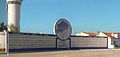 Monument to the Carnation Revolution
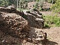 Roman Dam of Pego da Moura


See also
- "Grândola, Vila Morena" – a song by José Afonso associated with the Carnation Revolution
References
- Instituto Nacional de Estatística
- "Áreas das freguesias, concelhos, distritos e país". Archived from the original on 2018-11-05. Retrieved 2018-11-05.
- "Grândola 24F/01C". APA. Retrieved 13 June 2021.
- Diário da República. "Law nr. 11-A/2013, page 552 54" (pdf) (in Portuguese). Retrieved 23 July 2014.
External links
Authority control | |
|---|---|
| General |
|
| National libraries | |
| Other |
|
This Setúbal location article is a stub. You can help Wikipedia by expanding it. |
На других языках
[de] Grândola
Grândola [.mw-parser-output .IPA a{text-decoration:none}ˈɡɾɐ̃dulɐ] ist eine Kreisstadt (Vila) und ein Kreis (Concelho) im Distrikt Setúbal mit 10.660 Einwohnern (Stand 30. Juni 2011). Es erlangte Bekanntheit als Namensgeber des Liedes Grândola, Vila Morena, das 1974 als Losung der Nelkenrevolution diente.- [en] Grândola
[es] Grândola
Grândola es un municipio portugués del Distrito de Setúbal, en la región del Alentejo y comunidad intermunicipal del Alentejo Litoral, con cerca de 13 823 habitantes (2021), una superficie de 805 km² y una densidad de población de 19 hab/km². Fue fundada en 1544. Su gentilicio es Grandolense. Está subdividida en 4 freguesias.[ru] Грандола
Гра́ндола (порт. Grândola; [gɾɐ̃dulɐ]) — посёлок городского типа в Португалии, центр одноимённого муниципалитета округа Сетубал. Численность населения — 10,4 тыс. жителей (посёлок), 14,5 тыс. жителей (муниципалитет). Посёлок входит в регион Алентежу, в субрегион Алентежу-Литорал. По старому административному делению входил в провинцию Байшу-Алентежу.Другой контент может иметь иную лицензию. Перед использованием материалов сайта WikiSort.org внимательно изучите правила лицензирования конкретных элементов наполнения сайта.
WikiSort.org - проект по пересортировке и дополнению контента Википедии