world.wikisort.org - Portugal
Armação de Pêra is a town (vila) and Portuguese parish (freguesia) in the municipality of Silves.[1] The population in 2011 was 4,867,[2] in an area of 7.99 km².[3] The village used to be called Pêra de Baixo or Lower Pêra[4] to distinguish it from the present Pêra, which was then named Pêra de Cima or Upper Pêra.[5]
Armação de Pêra | |
|---|---|
Civil parish | |
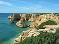
 Beach of Armação de Pêra | |
 Flag  Coat of arms | |
 Armação de Pêra Location in Portugal | |
| Coordinates: 37.102°N 8.361°W | |
| Country | |
| Region | Algarve |
| Intermunic. comm. | Algarve |
| District | Faro |
| Municipality | Silves |
| Area | |
| • Total | 7.99 km2 (3.08 sq mi) |
| Population (2011) | |
| • Total | 4,867 |
| • Density | 610/km2 (1,600/sq mi) |
| Time zone | UTC±00:00 (WET) |
| • Summer (DST) | UTC+01:00 (WEST) |
| Postal code | 8365 |
The town (vila in Portuguese) of Armação de Pêra is a popular tourist center with fine beaches, hotels, cafés and restaurants.[5] It is on a broad bay that stretches from Pont da Galé to Senhora da Rocha. Its beaches[6] extend from Praia dos Pescadores[6] or the Fishermen's Beach, to Salomão beach,[6] including those of Maré Grande[6] and Beijinhos.[5]
The town is one of the last places in the region where fishing boats are launched from and recovered to the actual beach. There is no harbour.
Location
The town is 20.9 kilometres (13.0 mi) southeast of Silves, 3 kilometres (1.9 mi) from Alcantarilha, 1.5 kilometres (0.93 mi) from Pêra and 263 kilometres (163 mi) south south east of Lisbon.[5]
Gallery
 Chapel of Santo António de Armação de Pêra


References
Notes
- Detail Regional Map, Algarve- Southern Portugal, ISBN 3-8297-6235-6
- Instituto Nacional de Estatística
- "Áreas das freguesias, concelhos, distritos e país". Archived from the original on 2018-11-05. Retrieved 2018-11-05.
- Grande enciclopédia portuguesa e brasileira: Actualização, Publisher: Zairol (1998) ISBN 972-9362-16-5
- Silves, Tourist Guide to the town and Borough, By J.D. Garcia Domingues,: Empresa Litográfica Do Sul, S.A.
- Algarve Spiral Guide:AA Publishing:ISBN 0-7495-3209-2
Parishes of Silves Municipality | ||
|---|---|---|
| Authority control |
|
|---|
This Faro location article is a stub. You can help Wikipedia by expanding it. |
На других языках
[de] Armação de Pêra
Armação de Pêra ist eine portugiesische Gemeinde im Kreis Silves mit 8,0 km² Fläche und 4867 Einwohnern (Stand 30. Juni 2011). Die Bevölkerungsdichte beträgt 609 Einwohner/km².- [en] Armação de Pêra
[ru] Армасан-ди-Пера
Армасан-ди-Пера (порт. Armação de Pêra) — район (фрегезия) в Португалии, входит в округ Фару. Является составной частью муниципалитета Силвеш. По старому административному делению входил в провинцию Алгарви. Входит в экономико-статистический субрегион Алгарви, который входит в Алгарви. Население составляет 3770 человек на 2001 год. Занимает площадь 9,15 км².Другой контент может иметь иную лицензию. Перед использованием материалов сайта WikiSort.org внимательно изучите правила лицензирования конкретных элементов наполнения сайта.
WikiSort.org - проект по пересортировке и дополнению контента Википедии