world.wikisort.org - Poland
Ostróda County (Polish: powiat ostródzki) is a unit of territorial administration and local government (powiat) in Warmian-Masurian Voivodeship, northern Poland. It came into being on January 1, 1999, as a result of the Polish local government reforms passed in 1998. Its administrative seat and largest town is Ostróda, which lies 37 kilometres (23 mi) west of the regional capital Olsztyn. The county contains three other towns: Morąg, 25 km (16 mi) north of Ostróda, Miłakowo, 34 km (21 mi) north of Ostróda, and Miłomłyn, 12 km (7 mi) north-west of Ostróda.
Ostróda County
Powiat ostródzki | |
|---|---|
County | |
 | |
 Flag  Coat of arms | |
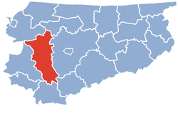 Location within the voivodeship | |
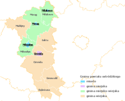 Division into gminas | |
| Coordinates (Ostróda): 53°42′N 19°58′E | |
| Country | Poland |
| Voivodeship | Warmian-Masurian |
| Seat | Ostróda |
| Gminas | |
| Area | |
| • Total | 1,764.89 km2 (681.43 sq mi) |
| Population (2006) | |
| • Total | 105,286 |
| • Density | 60/km2 (150/sq mi) |
| • Urban | 52,886 |
| • Rural | 52,400 |
| Car plates | NOS |
| Website | http://www.powiat.ostroda.pl/en/ |
The county covers an area of 1,764.89 square kilometres (681.4 sq mi). As of 2006 its total population is 105,286, out of which the population of Ostróda is 33,419, that of Morąg is 14,497, that of Miłakowo is 2,665, that of Miłomłyn is 2,305, and the rural population is 52,400.
Neighbouring counties
Ostróda County is bordered by Lidzbark County to the north-east, Olsztyn County to the east, Nidzica County to the south-east, Działdowo County to the south, Iława County and Sztum County to the west, and Elbląg County to the north-west.
Administrative division
The county is subdivided into nine gminas (one urban, three urban-rural and five rural). These are listed in the following table, in descending order of population.
| Gmina | Type | Area (km²) |
Population (2006) |
Seat |
| Ostróda | urban | 14.2 | 33,419 | |
| Gmina Morąg | urban-rural | 310.6 | 24,886 | Morąg |
| Gmina Ostróda | rural | 401.1 | 15,501 | Ostróda * |
| Gmina Małdyty | rural | 188.9 | 6,281 | Małdyty |
| Gmina Miłakowo | urban-rural | 159.4 | 5,736 | Miłakowo |
| Gmina Grunwald | rural | 179.8 | 5,648 | Gierzwałd |
| Gmina Miłomłyn | urban-rural | 160.9 | 4,988 | Miłomłyn |
| Gmina Łukta | rural | 184.7 | 4,458 | Łukta |
| Gmina Dąbrówno | rural | 165.4 | 4,369 | Dąbrówno |
| * seat not part of the gmina | ||||
Historical population
In 1828 Ostróda County (Kreis Osterode) had 32845 inhabitants, including by mother tongue: 23577 (~72%) Polish and 9268 (~28%) German.[1][2][3]
References
- von Haxthausen, August (1839). Die ländliche verfassung in den einzelnen provinzen der Preussischen Monarchie (in German). Königsberg: Gebrüder Borntraeger Verlagsbuchhandlung. pp. 78–81.
- Belzyt, Leszek (1996). "Zur Frage des nationalen Bewußtseins der Masuren im 19. und 20. Jahrhundert (auf der Basis statistischer Angaben)". Zeitschrift für Ostmitteleuropa-Forschung (in German). Bd. 45, Nr. 1: 35–71. Archived from the original on October 3, 2019. Retrieved December 4, 2019 – via zfo-online.
- Jasiński, Grzegorz (2009). "Statystyki językowe powiatów mazurskich z pierwszej połowy XIX wieku (do 1862 roku)" (PDF). Komunikaty Mazursko-Warmińskie (in Polish). 1: 97–130 – via BazHum.
Gminas of Ostróda County | ||
|---|---|---|
Seat: Ostróda (urban gmina) | ||
| Urban-rural gminas |  | |
| Rural gminas | ||
Counties of Warmian-Masurian Voivodeship | ||
|---|---|---|
| City counties |  | |
| Land counties | ||
На других языках
[de] Powiat Ostródzki
Der Powiat Ostródzki ist ein Powiat (Kreis) in der polnischen Woiwodschaft Ermland-Masuren mit dem Sitz in Ostróda. Der Powiat hat eine Fläche von 1764,9 km², auf der etwa 104.500 Einwohner leben.- [en] Ostróda County
[ru] Острудский повет
Острудский повет (польск. Powiat ostródzki) — повет (район) в Польше, входит как административная единица в Варминьско-Мазурское воеводство. Центр повета — город Оструда. Занимает площадь 1764,89 км². Население — 106 023 человек (на 31 декабря 2015 года)[1].Другой контент может иметь иную лицензию. Перед использованием материалов сайта WikiSort.org внимательно изучите правила лицензирования конкретных элементов наполнения сайта.
WikiSort.org - проект по пересортировке и дополнению контента Википедии