world.wikisort.org - Pakistan
Kalam (Kalami, Pashto, & Urdu: کالام) is a valley located 99 kilometres (62 mi) from Mingora in the northern upper section of Swat valley along the banks of the Swat River in the Khyber Pakhtunkhwa province of Pakistan.[2][3] The Swat River was formed as a result of the confluence of two major tributaries, the Gabral and Ushu river.[4][5]
This article has multiple issues. Please help improve it or discuss these issues on the talk page. (Learn how and when to remove these template messages)
|
Kalam | |
|---|---|
Valley | |
| کالام | |
 Kalam Valley | |
 Kalam  Kalam | |
| Coordinates: 35.4801°N 72.5874°E | |
| Country | Pakistan |
| Province | Khyber Pakhtunkhwa |
| District | Swat |
| Elevation | 2,001 m (6,565 ft) |
| Population (2017)[1] | |
| • Total | 23,170 |
| Time zone | UTC+5 (PST) |
At an elevation of about 2,000 m (6,600 ft) above sea level, the valley itself provides room for a plateau that is located above the river and used for farming.[6] There are mountains that are also visible from Matiltan, a valley close to Kalam Valley, including Mount Falaksar 5,918 meters (19,416 feet), and another unnamed peak 6,096 meters (20,000 feet) high.[7]
Climate
With a mild and generally warm and temperate climate, Kalam features a humid subtropical climate (Cfa) under the Köppen climate classification. The average temperature in Kalam is 13.4 °C (56.1 °F), while the annual precipitation averages 639 mm (25.16 in). November is the driest month with 15 mm (0.59 in) of precipitation, while April, the wettest month, has an average precipitation of 93 mm (3.66 in).
July is the hottest month of the year with an average temperature of 24.1 °C (75.4 °F). The coldest month, January, has an average temperature of 1.5 °C (34.7 °F).
| Climate data for Kalam | |||||||||||||
|---|---|---|---|---|---|---|---|---|---|---|---|---|---|
| Month | Jan | Feb | Mar | Apr | May | Jun | Jul | Aug | Sep | Oct | Nov | Dec | Year |
| Average high °C (°F) | 6.9 (44.4) |
8.0 (46.4) |
12.2 (54.0) |
18.0 (64.4) |
22.8 (73.0) |
26.1 (79.0) |
26.4 (79.5) |
25.7 (78.3) |
23.8 (74.8) |
19.6 (67.3) |
13.9 (57.0) |
9.6 (49.3) |
17.8 (63.9) |
| Daily mean °C (°F) | −0.4 (31.3) |
1.0 (33.8) |
5.2 (41.4) |
10.8 (51.4) |
15.3 (59.5) |
18.5 (65.3) |
20.1 (68.2) |
19.4 (66.9) |
16.4 (61.5) |
11.7 (53.1) |
6.6 (43.9) |
2.4 (36.3) |
10.6 (51.0) |
| Average low °C (°F) | −7.6 (18.3) |
−5.9 (21.4) |
−1.7 (28.9) |
3.7 (38.7) |
7.8 (46.0) |
11.0 (51.8) |
13.8 (56.8) |
13.1 (55.6) |
9.0 (48.2) |
3.8 (38.8) |
−0.7 (30.7) |
−4.7 (23.5) |
3.5 (38.2) |
| Average rainfall mm (inches) | 49 (1.9) |
66 (2.6) |
88 (3.5) |
93 (3.7) |
64 (2.5) |
32 (1.3) |
66 (2.6) |
66 (2.6) |
41 (1.6) |
28 (1.1) |
15 (0.6) |
31 (1.2) |
639 (25.2) |
| Source: PMD | |||||||||||||
Lakes
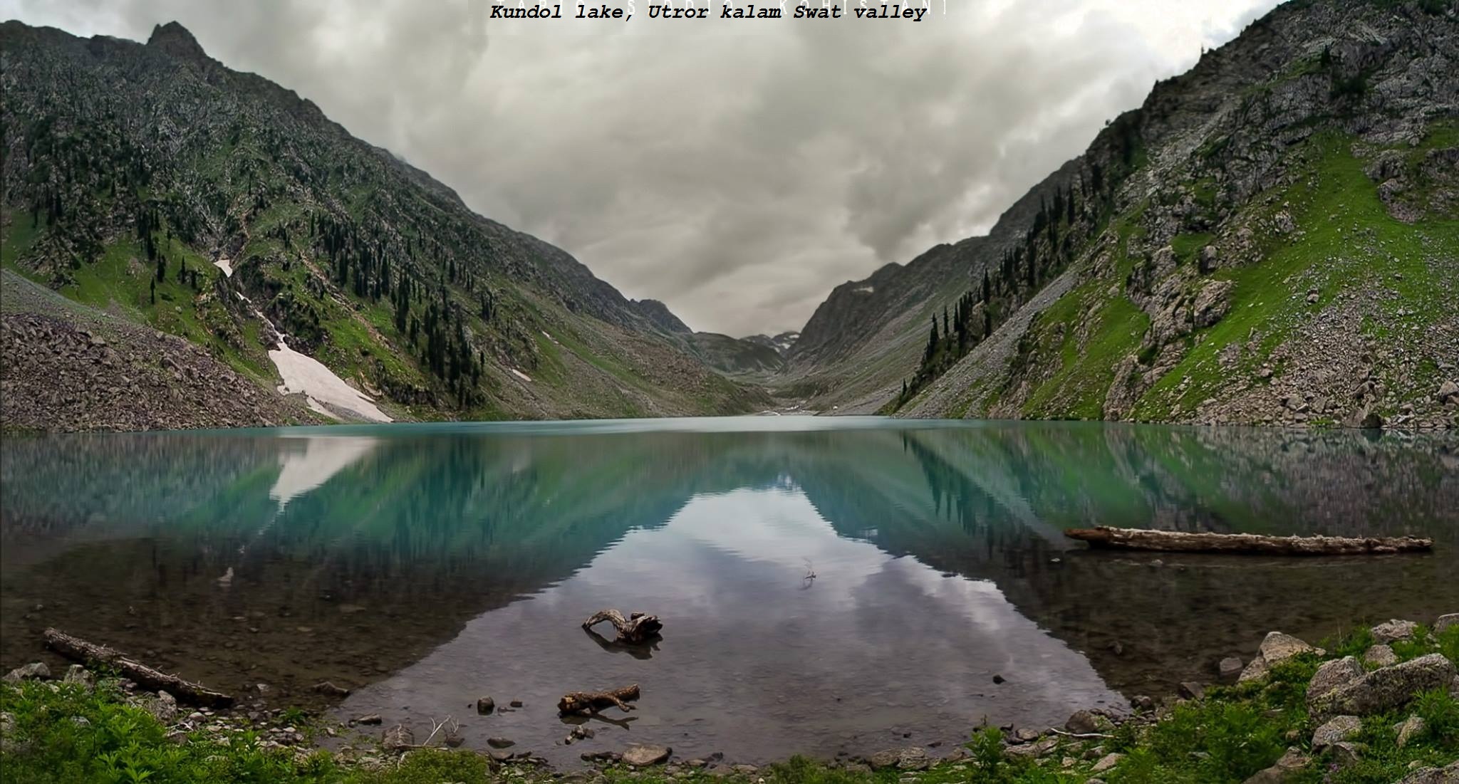
Kalam has large number of alpine glacial lakes. Two notable lakes in the Kalam Valley are the Mahodand lake and Kundol lake, both of which are frequently visited due to their easy access routes. Other lakes in the region, such as Izmis lake, are harder to enter and need to be done so on foot.
Mahodand Lake is a large lake in the Swat Valley, located approximately 40 km from Kalam, in the Usho Sub-valley at the base of the Hindu Kush mountains.
Another notable lake in the Kalam Valley is the Kundol Lake located in the north of Utror region, 19 km away from Kalam. It is located at the base of the Hindu Kush mountains.
Gallery


See also
- Bahrain, Swat
- Kumrat Valley
- Mahodand Lake
- Swat Valley
- Kalam summer festival
- Tourism in Khyber Pakhtunkhwa
References
- "POPULATION AND HOUSEHOLD DETAIL FROM BLOCK TO DISTRICT LEVEL: KHYBER PAKHTUNKHWA" (PDF). Pakistan Bureau of Statistics. 3 January 2018. Retrieved 23 April 2018.
- "Kalam Valley in Swat District, Khyber Pakhtunkhwa and Distance from Mingora". Pakistantravelguide.pk. Retrieved 22 July 2018.
- "Kalam Valley, Swat District, Khyber Pakhtunkhwa". www.worldfortravel.com. Retrieved 22 July 2018.
- "Birthplace of Swat and Surrounded by Green Hills and Thick Forest". Destinations.com.pk. 24 February 2017. Retrieved 22 July 2018.
- Hassan, Ali (7 August 2015). "Kalam — As memories of war fade..." Dawn. Retrieved 30 October 2020.
- Tourists Guide >> Places to Visit >> Kalam Publisher: swat valley.com, Retrieved on 29 September 2012
- Archived at Ghostarchive and the Wayback Machine: "Kalam From Above.......Pakistan HD". YouTube.
Administrative divisions of Swat District | ||
|---|---|---|
| Tehsils |
| |
| Union councils |
| |
Другой контент может иметь иную лицензию. Перед использованием материалов сайта WikiSort.org внимательно изучите правила лицензирования конкретных элементов наполнения сайта.
WikiSort.org - проект по пересортировке и дополнению контента Википедии