world.wikisort.org - Norvegia
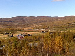
Gausdal è un comune norvegese della contea di Innlandet, distretto di Gudbrandsdalen.
| Gausdal comune | ||
|---|---|---|
| ||
 | ||
| Localizzazione | ||
| Stato | ||
| Regione | Østlandet | |
| Contea | ||
| Amministrazione | ||
| Capoluogo | Segalstad bru | |
| Sindaco | Olav Olstad (Sp) | |
| Lingue ufficiali | Norvegese neutrale | |
| Territorio | ||
| Coordinate del capoluogo | 61°16′36″N 9°55′21″E | |
| Superficie | 1 192 km² | |
| Abitanti | 6 023[1] (1 gennaio 2021) | |
| Densità | 5,05 ab./km² | |
| Altre informazioni | ||
| Fuso orario | UTC+1 | |
| Codice SSB | 3441 | |
| Nome abitanti | Gausdøl | |
| Cartografia | ||
 | ||
| Sito istituzionale | ||
Note
Altri progetti
 Wikimedia Commons contiene immagini o altri file su Gausdal
Collegamenti esterni
- (NB) Sito ufficiale, su gausdal.kommune.no.
| Controllo di autorità | VIAF (EN) 123159642 · ISNI (EN) 0000 0004 1792 5413 · LCCN (EN) n80162581 · WorldCat Identities (EN) lccn-n80162581 |
|---|
На других языках
[de] Gausdal
Die Kommune Gausdal in Norwegen hat eine Fläche von 1190 km² mit einer Nord-Süd-Ausdehnung von 34,5 km und einer Ost-West-Ausdehnung von 57,2 km. Gausdal hat 6079 Einwohner (Stand 1. Januar 2022). Die Kommune liegt im Fylke Innlandet westlich des mittleren Gudbrandsdals und wird von dem Ort Segalstad bru verwaltet. Größere Siedlungen in Gausdal sind Follebu, Forset und Segalstad bru. Die höchste Erhebung ist die nordre Langsua mit einer Höhe von 1554 moh.[2] Jährlich finden in Gausdal stark besetzte Schachturniere statt.[en] Gausdal
Gausdal is a municipality in Innlandet county, Norway. It is located in the traditional district of Gudbrandsdal. The administrative centre of the municipality is the village of Segalstad bru. Other villages in Gausdal include Follebu, Forset, and Svingvoll.- [it] Gausdal
[ru] Гёусдал
Гёусдал (норв. Gausdal) — коммуна в губернии Оппланн в Норвегии. Административный центр коммуны — город Сегалстад-бру. Официальный язык коммуны — нейтральный[1]. Население коммуны на 2007 год составляло 6129 чел. Площадь коммуны Гёусдал — 1191,63 км², код-идентификатор — 0522.Текст в блоке "Читать" взят с сайта "Википедия" и доступен по лицензии Creative Commons Attribution-ShareAlike; в отдельных случаях могут действовать дополнительные условия.
Другой контент может иметь иную лицензию. Перед использованием материалов сайта WikiSort.org внимательно изучите правила лицензирования конкретных элементов наполнения сайта.
Другой контент может иметь иную лицензию. Перед использованием материалов сайта WikiSort.org внимательно изучите правила лицензирования конкретных элементов наполнения сайта.
2019-2025
WikiSort.org - проект по пересортировке и дополнению контента Википедии
WikiSort.org - проект по пересортировке и дополнению контента Википедии

