world.wikisort.org - Norway
Sørvågen is a fishing village in Moskenes Municipality in Nordland county, Norway. It is located on the island of Moskenesøya in the Lofoten archipelago. The village of Å lies just to the south. Moskenes Church is located just north of the village along European route E10.[3]
Sørvågen | |
|---|---|
Village | |
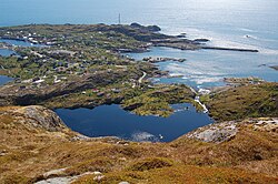
 View of the western part of the village | |
 Sørvågen Location in Nordland  Sørvågen Sørvågen (Norway) | |
| Coordinates: 67.8897°N 13.0164°E | |
| Country | Norway |
| Region | Northern Norway |
| County | Nordland |
| District | Lofoten |
| Municipality | Moskenes |
| Area | |
| • Total | 0.63 km2 (0.24 sq mi) |
| Elevation | 12 m (39 ft) |
| Population (2018)[1] | |
| • Total | 440 |
| • Density | 698/km2 (1,810/sq mi) |
| Time zone | UTC+01:00 (CET) |
| • Summer (DST) | UTC+02:00 (CEST) |
| Post Code | 8392 Sørvågen |
The 0.63-square-kilometre (160-acre) village has a population (2018) of 440 which gives the village a population density of 698 inhabitants per square kilometre (1,810/sq mi).[1]
Tourism

The village has several scenic and tourist attractions in and around the village. It contains a local department of the Norsk Telemuseum (Norwegian Telecom Museum) which reflects the local history of telegraphy.
In 1861, the island became part of the 170-kilometre-long (110 mi) Lofoten telegraph line with a station in Sørvågen (which became the Sørvågen museum in 1914), being finally connected with Europe in 1867.
In 1906, a wireless telegraph system was installed in Sørvågen—the second in Europe after Italy—connecting Sørvågen with Røst.[4]
References
- Statistisk sentralbyrå (1 January 2018). "Urban settlements. Population and area, by municipality".
- "Sørvågen, Moskenes (Nordland)". yr.no. Retrieved 9 December 2018.
- Store norske leksikon. "Sørvågen" (in Norwegian). Retrieved 13 June 2012.
- Filippo, H.; Pelzers, E. (2007). Noord Scandinavië: Lapland, Noordkaap, Lofoten, Spitsbergen (in Dutch). Uitgeverij Elmar. p. 150. ISBN 978-90-389-1745-0.
External links
 Media related to Sørvågen at Wikimedia Commons
На других языках
- [en] Sørvågen, Moskenes
[ru] Сёрвоген (Москенес)
Сёрвоген (норв. Sørvågen) — рыбацкая деревня в коммуне Москенес на Лофотенских островах, Норвегия с несколькими достопримечательностями местного пейзажа.Другой контент может иметь иную лицензию. Перед использованием материалов сайта WikiSort.org внимательно изучите правила лицензирования конкретных элементов наполнения сайта.
WikiSort.org - проект по пересортировке и дополнению контента Википедии