world.wikisort.org - Norway
Longva is a village in Ålesund Municipality in Møre og Romsdal county, Norway. The village is located on the southwest side of the island of Skuløya, along the Longvafjorden. It is about 12 kilometres (7.5 mi) northeast of the village of Austnes on Haramsøya via the Ullasund Bridge. The population (2003) was 637, but since 2004, Longva has not been considered an urban settlement by Statistics Norway, and its data is therefore not registered.[2][3]
Longva | |
|---|---|
Village | |
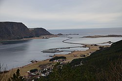
 Longva is in the lower foreground of the picture. | |
 Longva Location in Møre og Romsdal  Longva Longva (Norway) | |
| Coordinates: 62.6647°N 6.2742°E | |
| Country | Norway |
| Region | Western Norway |
| County | Møre og Romsdal |
| District | Sunnmøre |
| Municipality | Ålesund Municipality |
| Elevation | 10 m (30 ft) |
| Time zone | UTC+01:00 (CET) |
| • Summer (DST) | UTC+02:00 (CEST) |
| Post Code | 6293 Longva |
References
- "Longva, Haram (Møre og Romsdal)". yr.no. Retrieved 2019-08-03.
- Statistisk sentralbyrå (1 January 2003). "Urban settlements. Population and area, by municipality". Archived from the original on 1 April 2007.
{{cite journal}}: Cite journal requires|journal=(help) - Statistisk sentralbyrå (1 January 2004). "New and omitted urban settlements". Archived from the original on 1 April 2007.
{{cite journal}}: Cite journal requires|journal=(help)
Текст в блоке "Читать" взят с сайта "Википедия" и доступен по лицензии Creative Commons Attribution-ShareAlike; в отдельных случаях могут действовать дополнительные условия.
Другой контент может иметь иную лицензию. Перед использованием материалов сайта WikiSort.org внимательно изучите правила лицензирования конкретных элементов наполнения сайта.
Другой контент может иметь иную лицензию. Перед использованием материалов сайта WikiSort.org внимательно изучите правила лицензирования конкретных элементов наполнения сайта.
2019-2025
WikiSort.org - проект по пересортировке и дополнению контента Википедии
WikiSort.org - проект по пересортировке и дополнению контента Википедии