world.wikisort.org - Norway
Hammarvika is a village in the municipality of Frøya in Trøndelag county, Norway. The village is located about 4 kilometres (2.5 mi) south of the municipal center of Sistranda on the southeastern side of the island of Frøya. The 0.58-square-kilometre (140-acre) village has a population (2018) of 461 and a population density of 795 inhabitants per square kilometre (2,060/sq mi).[1]
Hammarvika | |
|---|---|
Village | |
  Hammarvika Location of the village 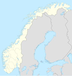 Hammarvika Hammarvika (Norway) | |
| Coordinates: 63.6958°N 08.8098°E | |
| Country | Norway |
| Region | Central Norway |
| County | Trøndelag |
| District | Fosen |
| Municipality | Frøya |
| Area | |
| • Total | 0.58 km2 (0.22 sq mi) |
| Elevation | 0.5 m (1.6 ft) |
| Population (2018)[1] | |
| • Total | 461 |
| • Density | 795/km2 (2,060/sq mi) |
| Time zone | UTC+01:00 (CET) |
| • Summer (DST) | UTC+02:00 (CEST) |
| Post Code | 7263 Hamarvik |
The Frøya Tunnel to the neighboring island of Hitra begins at Hammarvika and goes underneath the Frøyfjorden to the south.
References
- Statistisk sentralbyrå (1 January 2018). "Urban settlements. Population and area, by municipality".
- "Hammarvika, Frøya (Trøndelag)". yr.no. Retrieved 2018-02-19.
 | This Trøndelag location article is a stub. You can help Wikipedia by expanding it. |
Текст в блоке "Читать" взят с сайта "Википедия" и доступен по лицензии Creative Commons Attribution-ShareAlike; в отдельных случаях могут действовать дополнительные условия.
Другой контент может иметь иную лицензию. Перед использованием материалов сайта WikiSort.org внимательно изучите правила лицензирования конкретных элементов наполнения сайта.
Другой контент может иметь иную лицензию. Перед использованием материалов сайта WikiSort.org внимательно изучите правила лицензирования конкретных элементов наполнения сайта.
2019-2026
WikiSort.org - проект по пересортировке и дополнению контента Википедии
WikiSort.org - проект по пересортировке и дополнению контента Википедии