world.wikisort.org - Norway
Høllen is a village in Lindesnes municipality in Agder county, Norway. The village is located on the narrow isthmus connecting the Lindesnes peninsula to the mainland, about 5 kilometres (3.1 mi) west of the village of Svenevig. The 0.72-square-kilometre (180-acre) village has a population (2015) of 648, giving the village a population density of 900 inhabitants per square kilometre (2,300/sq mi).[1]
Høllen
Spangereid | |
|---|---|
Village | |
 Høllen Location of the village  Høllen Høllen (Norway) | |
| Coordinates: 58°02′43″N 07°08′38″E | |
| Country | Norway |
| Region | Southern Norway |
| County | Agder |
| District | Lindesnes |
| Municipality | Lindesnes |
| Area | |
| • Total | 0.72 km2 (0.28 sq mi) |
| Elevation | 4 m (13 ft) |
| Population (2015)[1] | |
| • Total | 648 |
| • Density | 900/km2 (2,000/sq mi) |
| Time zone | UTC+01:00 (CET) |
| • Summer (DST) | UTC+02:00 (CEST) |
| Post Code | 4521 Lindesnes |
Høllen was the administrative centre of the old municipality of Spangereid which existed from 1889 until 1965. The village is also known as Spangereid since it was the centre of Spangereid for nearly a century and prior to that it was the seat of the parish of Spangereid since Spangereid Church is located in Høllen.[3]
In 2007, the Spangereid Canal was completed through the centre of Høllen. The 0.93-kilometre (0.58 mi) long canal crosses the isthmus connecting the Lindesnes peninsula to the mainland. The canal connects the Lenesfjorden to the North Sea.
The area is one of Norway's richest archaeological sites. The abundant remnants from the Bronze Age and Viking Age show the Spangereid was a very important place at that time. Today, the village is a popular tourist destination for Norwegians and Europeans alike.
Photo gallery
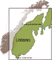 Map of the Spangereid area
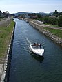 Spangereid Canal
 Central part of Høllen
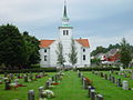 Spangereid Church


References
- Statistisk sentralbyrå (1 January 2015). "Urban settlements. Population and area, by municipality".
- "Høllen, Lindesnes (Vest-Agder)". yr.no. Retrieved 8 December 2016.
- Store norske leksikon. "Høllen – tettsted" (in Norwegian). Retrieved 8 December 2016.
Authority control | |
|---|---|
| General |
|
| National libraries | |
This Agder location article is a stub. You can help Wikipedia by expanding it. |
Другой контент может иметь иную лицензию. Перед использованием материалов сайта WikiSort.org внимательно изучите правила лицензирования конкретных элементов наполнения сайта.
WikiSort.org - проект по пересортировке и дополнению контента Википедии