world.wikisort.org - Norway
Eidsdal is a village and valley in Fjord Municipality in Møre og Romsdal county, Norway. It is located along the south side of the Norddalsfjorden, about 7 kilometres (4.3 mi) southwest of the municipal centre of Sylte and the village of Norddal lies about 4 kilometres (2.5 mi) east of Eidsdal. The local church, Norddal Church is located in nearby Norddal village. Eidsdal has approximately 400 inhabitants.[2]
This article may be expanded with text translated from the corresponding article in Norwegian. (September 2012) Click [show] for important translation instructions.
|
Eidsdal | |
|---|---|
Village | |
 View of Eidsdal (looking north) | |
 Eidsdal Location in Møre og Romsdal  Eidsdal Eidsdal (Norway) | |
| Coordinates: 62.2626°N 7.1718°E | |
| Country | Norway |
| Region | Western Norway |
| County | Møre og Romsdal |
| District | Sunnmøre |
| Municipality | Fjord Municipality |
| Elevation | 3 m (10 ft) |
| Time zone | UTC+01:00 (CET) |
| • Summer (DST) | UTC+02:00 (CEST) |
| Post Code | 6215 Eidsdal |
The valley stretches from the Norddalsfjorden up to the lake Eidsvatnet in the direction of Geiranger. Eidsdal is part of "The Golden Route", a well known tourist route that connects Eidsdal and Geiranger with Romsdal and Trollstigen.[3] Norwegian County Road 63 runs north and south through the Eidsdal valley, with a ferry connection to Linge, across the fjord.
Eidsdal is mainly an agricultural village. Most farmers are engaged in milk production with cows and goats. Tourism is the second major economic activity in Eidsdal. There are several campgrounds, cabins, and room rentals. Furthermore, there has been considerable investment in building cabins in recent years.
Gallery
 Eidsdalen from a little south from the Oppskredtunnelen
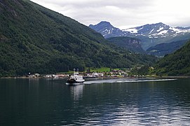

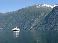 Ferry from Linge to Eidsdal
 Eidsvatnet


References
- "Eidsdal, Norddal (Møre og Romsdal)". yr.no. Retrieved 2019-08-18.
- Store norske leksikon. "Eidsdal" (in Norwegian). Retrieved 2010-10-15.
- "The National Tourist Route – The Golden Route". Destination Ålesund & Sunnmøre and Destination Geirangerfjord. Retrieved 2010-10-15.
This Møre og Romsdal location article is a stub. You can help Wikipedia by expanding it. |
Другой контент может иметь иную лицензию. Перед использованием материалов сайта WikiSort.org внимательно изучите правила лицензирования конкретных элементов наполнения сайта.
WikiSort.org - проект по пересортировке и дополнению контента Википедии