world.wikisort.org - Norway
Bærumsmarka is a forested recreational area located outside Oslo, Norway. The area constitutes part of Oslomarka and is bordered by Krokskogen and Nordmarka.[1]
Bærumsmarka | |
|---|---|
Forest | |
| Coordinates: 59°58′46″N 10°31′17″E | |
| Country | Norway |
| Region | Østlandet |
| County | Viken |
| Time zone | UTC+01:00 (CET) |
| • Summer (DST) | UTC+02:00 (CEST) |
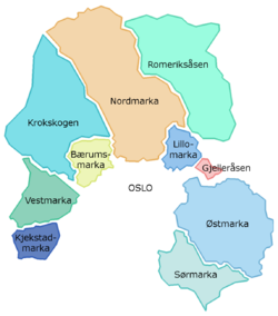
Bærumsmarka is in the Bærum municipality of Viken. It is situated between the valleys of Lommedalen and Sørkedalen. Bærumsmarka is laced by over 70 square kilometres of marked hiking, riding and ski trails. The highest point in the landscape is Tjæregrashøgda (485 m). The area was a site of coal mining in connection with an iron network operation from the mid-1600s to the mid-1800s. The association Bærumsmarkas Venner was formed in 1985 to preserve the area against future development.[2]
References
- Knut Are Tvedt. "Bærumsmarka". Store norske leksikon. Retrieved September 15, 2016.
- "Bærumsmarka". skiforeningen.no. Retrieved September 15, 2016.
Other sources
- Christensen, Trygve (1988) Bærumsmarka før og nå (Oslo: Gyldendal) ISBN 82-05-17714-7
This Viken location article is a stub. You can help Wikipedia by expanding it. |
Текст в блоке "Читать" взят с сайта "Википедия" и доступен по лицензии Creative Commons Attribution-ShareAlike; в отдельных случаях могут действовать дополнительные условия.
Другой контент может иметь иную лицензию. Перед использованием материалов сайта WikiSort.org внимательно изучите правила лицензирования конкретных элементов наполнения сайта.
Другой контент может иметь иную лицензию. Перед использованием материалов сайта WikiSort.org внимательно изучите правила лицензирования конкретных элементов наполнения сайта.
2019-2026
WikiSort.org - проект по пересортировке и дополнению контента Википедии
WikiSort.org - проект по пересортировке и дополнению контента Википедии