world.wikisort.org - Nigeria
Kagoma is a district of Jema'a Local Government Area, southern Kaduna state in the Middle Belt region of Nigeria.[2] The postal code for the village is 801104.[3][4][5]


Kagoma
Gwong | |
|---|---|
District | |
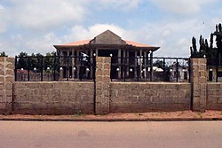
 Kpop Gwong's new palace under construction | |
| Nickname: K10 | |
 Kagoma | |
| Coordinates: 09°31′N 08°11′E[1] | |
| Country | |
| State | Kaduna State |
| LGA | Jema'a |
| Government | |
| • Kpop Gwong | Kpop (Col.) Paul Zakka Wyom (rtd.) |
| Time zone | UTC+01:00 (WAT) |
| Climate | Aw |
People
Language
Transportation

The major means of transportation in and around the town is road transportation.
References
- "Fadan Kagoma Map - Satellite Images of Fadan Kagoma". maplandia.com. Retrieved September 25, 2020.
- "Kagoma, Jema'A, Kaduna State, Nigeria". mindat.org. Retrieved September 25, 2020.
- "Nigeria Postcode". Retrieved September 25, 2020.
- "Post Offices- with map of LGA". NIPOST. Archived from the original on 2009-10-07. Retrieved 2020-09-25.
- "Kagoma/Asso Post Codes: Nigeria". World Postal Code. Retrieved September 25, 2020.
External links
![]() Media related to Kagoma, Nigeria at Wikimedia Commons
Media related to Kagoma, Nigeria at Wikimedia Commons
Текст в блоке "Читать" взят с сайта "Википедия" и доступен по лицензии Creative Commons Attribution-ShareAlike; в отдельных случаях могут действовать дополнительные условия.
Другой контент может иметь иную лицензию. Перед использованием материалов сайта WikiSort.org внимательно изучите правила лицензирования конкретных элементов наполнения сайта.
Другой контент может иметь иную лицензию. Перед использованием материалов сайта WikiSort.org внимательно изучите правила лицензирования конкретных элементов наполнения сайта.
2019-2025
WikiSort.org - проект по пересортировке и дополнению контента Википедии
WikiSort.org - проект по пересортировке и дополнению контента Википедии