world.wikisort.org - Netherlands
Swartbroek (Dutch pronunciation: [ˈsʋɑrdbruk]; Limburgish: Zwertbrook [ˈzwe̞ʀdbʀoːk]) is a village in the Netherlands, in the municipality of Weert in the province of Limburg.
Swartbroek | |
|---|---|
Village | |
 St Cornelius Church | |
 Swartbroek Location in the Netherlands  Swartbroek Location in the province of Limburg in the Netherlands | |
| Coordinates: 51°14′N 5°46′E | |
| Country | Netherlands |
| Province | Limburg |
| Municipality | Weert |
| Area | |
| • Total | 6.98 km2 (2.69 sq mi) |
| Elevation | 32 m (105 ft) |
| Population (2021)[1] | |
| • Total | 870 |
| • Density | 120/km2 (320/sq mi) |
| Time zone | UTC+1 (CET) |
| • Summer (DST) | UTC+2 (CEST) |
| Postal code | 6005[1] |
| Dialing code | 0495 |
| Major roads | A2 N280 |
The village was first mentioned in the 16th century as Swartbroeck, and means "black swampy land".[3]
Swartbroek was home to 276 people in 1840. In 1925, the St Cornelius Church was built. The grist mill De Hoop was built in 1905 using material from a 1788 wind mill. Between 2011 and 2015, it was restored and still in active service.[4]
Gallery
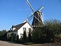 Windmill De Hoop
 Tea pot museum


References
- "Kerncijfers wijken en buurten 2021". Central Bureau of Statistics. Retrieved 26 April 2022.
- "Postcodetool for 6005AA". Actueel Hoogtebestand Nederland (in Dutch). Het Waterschapshuis. Retrieved 26 April 2022.
- "Swartbroek". Etymologiebank (in Dutch). Retrieved 26 April 2022.
- "Swartbroek". Plaatsengids (in Dutch). Retrieved 26 April 2022.
Wikimedia Commons has media related to Swartbroek.
This Dutch Limburg location article is a stub. You can help Wikipedia by expanding it. |
Текст в блоке "Читать" взят с сайта "Википедия" и доступен по лицензии Creative Commons Attribution-ShareAlike; в отдельных случаях могут действовать дополнительные условия.
Другой контент может иметь иную лицензию. Перед использованием материалов сайта WikiSort.org внимательно изучите правила лицензирования конкретных элементов наполнения сайта.
Другой контент может иметь иную лицензию. Перед использованием материалов сайта WikiSort.org внимательно изучите правила лицензирования конкретных элементов наполнения сайта.
2019-2026
WikiSort.org - проект по пересортировке и дополнению контента Википедии
WikiSort.org - проект по пересортировке и дополнению контента Википедии