world.wikisort.org - Netherlands
Stramproy (Limburgish: Rooj, pronounced [ˈʀoːj] is a village in the Dutch province of Limburg. It is located in the municipality of Weert.
Stramproy
Rooj | |
|---|---|
Village | |
 Former water tower | |
 Stramproy Location in the Netherlands  Stramproy Location in the province of Limburg in the Netherlands | |
| Coordinates: 51°11′36″N 5°43′9″E | |
| Country | Netherlands |
| Province | |
| Municipality | |
| Area | |
| • Total | 12.14 km2 (4.69 sq mi) |
| Elevation | 32 m (105 ft) |
| Population (2021)[1] | |
| • Total | 5,105 |
| • Density | 420/km2 (1,100/sq mi) |
| Time zone | UTC+1 (CET) |
| • Summer (DST) | UTC+2 (CEST) |
| Postal code | 6039[1] |
| Dialing code | 0495 |
| Major roads | N292 |
History
The village was first mentioned in 1299 as Stramprode.[3] Stramproy developed in the Early Middle Ages on the edge of the Peel region.[4]
The St Willibrordus Church is a three aisled church built between 1922 and 1923 as a replacement of the medieval church. It has a tower on the side with a large needle spire. The tower was built in the 14th century and the spire was added around 1700.[4]
Stramproy was a separate municipality until 1998, when it was merged with Weert.[5]
Location
Stramproy lies near the Dutch/Belgian border, about five kilometers south of the city limits of Weert. The provincial road N292 runs through the village in a north-south direction and connects to the Belgian N762 at the border, which leads to the city of Maaseik. To the north, between Stramproy and Weert, lies the smaller village of Tungelroy.
Gallery
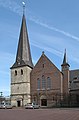 Stramproy, church
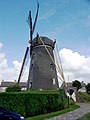 Windmill Molen van Nijs
 House Tramhalt
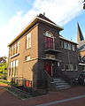 Former town hall


References
- "Kerncijfers wijken en buurten 2021". Central Bureau of Statistics. Retrieved 26 April 2022.
- "Postcodetool for 6039AA". Actueel Hoogtebestand Nederland (in Dutch). Het Waterschapshuis. Retrieved 26 April 2022.
- "Stramproy - (geografische naam)". Etymologiebank (in Dutch). Retrieved 26 April 2022.
- Sabine Broekhoven, & Ronald Stenvert (2003). Stramproy (in Dutch). Zwolle: Waanders. ISBN 90 400 9623 6. Retrieved 26 April 2022.
- Ad van der Meer and Onno Boonstra, Repertorium van Nederlandse gemeenten, KNAW, 2011.
This Dutch Limburg location article is a stub. You can help Wikipedia by expanding it. |
Другой контент может иметь иную лицензию. Перед использованием материалов сайта WikiSort.org внимательно изучите правила лицензирования конкретных элементов наполнения сайта.
WikiSort.org - проект по пересортировке и дополнению контента Википедии