world.wikisort.org - Netherlands
Oudenhoorn is a village in the Dutch province of South Holland. It is part of the municipality of Hellevoetsluis and lies about 3 km east of Hellevoetsluis.
Oudenhoorn | |
|---|---|
Village | |
 Dutch Reformed church | |
 Coat of arms | |
 Oudenhoorn Location in the province of South Holland in the Netherlands  Oudenhoorn Location in the Netherlands | |
| Coordinates: 51°50′N 4°12′E | |
| Country | Netherlands |
| Province | South Holland |
| Municipality | Hellevoetsluis |
| Area | |
| • Total | 9.69 km2 (3.74 sq mi) |
| Elevation | −0.4 m (−1.3 ft) |
| Population (2021)[1] | |
| • Total | 1,225 |
| • Density | 130/km2 (330/sq mi) |
| Time zone | UTC+1 (CET) |
| • Summer (DST) | UTC+2 (CEST) |
| Postal code | 3227[1] |
| Dialing code | 0181 |
The village was first mentioned in 1356 as "den Hoorn". The current name means "old corner (of a dike)". The eponymous polder was created in 1356 by order of Machteld van Voorne. Oud (old) has been added to distinguish from Nieuwenhoorn.[3]
Oudenhoorn was an independent municipality until 1980 when it was merged into Bernisse. In 2015, it became part of Hellevoetsluis.[4]
Gallery
 Farm in Oudenhoorn
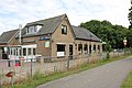 Former tram station. Nowadays pub
 Street view
 Farm in Oudenhoorn


References
- "Kerncijfers wijken en buurten 2021". Central Bureau of Statistics. Retrieved 3 May 2022.
- "Postcodetool for 3227AA". Actueel Hoogtebestand Nederland (in Dutch). Het Waterschapshuis. Retrieved 3 May 2022.
- "Oudenhoorn - (geografische naam)". Etymologiebank (in Dutch). Retrieved 3 May 2022.
- "Oudenhoorn". Plaatsengids (in Dutch). Retrieved 3 May 2022.
Wikimedia Commons has media related to Oudenhoorn.
Authority control | |
|---|---|
| General |
|
| National libraries | |
This South Holland location article is a stub. You can help Wikipedia by expanding it. |
Текст в блоке "Читать" взят с сайта "Википедия" и доступен по лицензии Creative Commons Attribution-ShareAlike; в отдельных случаях могут действовать дополнительные условия.
Другой контент может иметь иную лицензию. Перед использованием материалов сайта WikiSort.org внимательно изучите правила лицензирования конкретных элементов наполнения сайта.
Другой контент может иметь иную лицензию. Перед использованием материалов сайта WikiSort.org внимательно изучите правила лицензирования конкретных элементов наполнения сайта.
2019-2026
WikiSort.org - проект по пересортировке и дополнению контента Википедии
WikiSort.org - проект по пересортировке и дополнению контента Википедии