world.wikisort.org - Netherlands
Ferwerderadiel (![]() pronunciation) is a former municipality of Friesland in the northern Netherlands. Its official name is West Frisian, the Dutch name is Ferwerderadeel (pronounced [fɛrˈʋɛrdəraːˌdeːl] (
pronunciation) is a former municipality of Friesland in the northern Netherlands. Its official name is West Frisian, the Dutch name is Ferwerderadeel (pronounced [fɛrˈʋɛrdəraːˌdeːl] (![]() listen)). In 2019 it merged with the municipalities of Dongeradeel and Kollumerland en Nieuwkruisland to form the new municipality Noardeast-Fryslân.
listen)). In 2019 it merged with the municipalities of Dongeradeel and Kollumerland en Nieuwkruisland to form the new municipality Noardeast-Fryslân.
Ferwerderadiel
Ferwerderadeel | |
|---|---|
Municipality | |
 Canal through Burdaard | |
 Flag Coat of arms | |
 Location in Friesland | |
| Coordinates: 53°20′N 5°50′E | |
| Country | Netherlands |
| Province | Friesland |
| Merged | 2019 |
| Area | |
| • Total | 133.18 km2 (51.42 sq mi) |
| • Land | 97.71 km2 (37.73 sq mi) |
| • Water | 35.47 km2 (13.70 sq mi) |
| Elevation | 1 m (3 ft) |
| Time zone | UTC+1 (CET) |
| • Summer (DST) | UTC+2 (CEST) |
| Postcode | 9070–9179 |
| Area code | 0518, 0519, 058 |
| Website | www |
Population centres
Bartlehiem, Blije, Burdaard, Ferwert, Ginnum, Hallum, Hegebeintum, Jannum, Jislum, Lichtaard, Marrum, Reitsum, Wânswert, Westernijtsjerk.
Topography

'Dutch topographic map of the municipality of Ferwerderadiel, June 2015
Notable people

- Saint Frederick of Hallum (ca. 1113 – 1175) a Premonstratensian priest
- Barthold Douma van Burmania (1695 in Hallum – 1766) a Dutch statesman and ambassador to the court of Vienna
- Pieter Boeles (1795 in Ferwerd – 1875) a Dutch Minister and linguist
- Gerardus Heymans (1857 in Ferwert – 1930) a Dutch philosopher, psychologist and academic
- Watse Cuperus (1891 in Blije – 1966) a Dutch journalist and writer in the West Frisian language
- Eeltsje Boates Folkertsma (1893 in Ferwert – 1968) a West Frisian language writer
- Maria Sterk (born 1979 in Hallum) a Dutch marathon speed skater
Gallery
 Birdaard, drawbridge and church
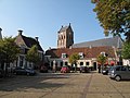 Ferwerd, Vrijhof and church
 Marrum, church
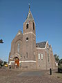 Hallum, church


References
- "Kerncijfers wijken en buurten 2020" [Key figures for neighbourhoods 2020]. StatLine (in Dutch). CBS. 24 July 2020. Retrieved 19 September 2020.
- "Postcodetool for 9172PJ". Actueel Hoogtebestand Nederland (in Dutch). Het Waterschapshuis. Archived from the original on 21 September 2013. Retrieved 8 September 2013.
External links
 Media related to Ferwerderadiel at Wikimedia Commons
- Official website
Places adjacent to Ferwerderadiel | ||||||||||||||||
|---|---|---|---|---|---|---|---|---|---|---|---|---|---|---|---|---|
| ||||||||||||||||
Authority control | |
|---|---|
| General | |
| National libraries | |
This Friesland location article is a stub. You can help Wikipedia by expanding it. |
Текст в блоке "Читать" взят с сайта "Википедия" и доступен по лицензии Creative Commons Attribution-ShareAlike; в отдельных случаях могут действовать дополнительные условия.
Другой контент может иметь иную лицензию. Перед использованием материалов сайта WikiSort.org внимательно изучите правила лицензирования конкретных элементов наполнения сайта.
Другой контент может иметь иную лицензию. Перед использованием материалов сайта WikiSort.org внимательно изучите правила лицензирования конкретных элементов наполнения сайта.
2019-2026
WikiSort.org - проект по пересортировке и дополнению контента Википедии
WikiSort.org - проект по пересортировке и дополнению контента Википедии