world.wikisort.org - Netherlands
Elst is a village in the central Netherlands. It is located in the municipality of Rhenen, Utrecht, about 5 km southwest of Veenendaal.
Elst | |
|---|---|
Village | |
 View of Elst from the other side of the Lower Rhine. | |
 Elst Location in the Netherlands  Elst Elst (Netherlands) | |
| Coordinates: 51°59′8″N 5°29′55″E | |
| Country | Netherlands |
| Province | Utrecht |
| Municipality | Rhenen |
| Area | |
| • Total | 10.13 km2 (3.91 sq mi) |
| Elevation | 10 m (30 ft) |
| Population (2021)[1] | |
| • Total | 4,650 |
| • Density | 460/km2 (1,200/sq mi) |
| Time zone | UTC+1 (CET) |
| • Summer (DST) | UTC+2 (CEST) |
| Postal code | 3921[1] |
| Dialing code | 0318 |
Until 1 January 2006, the western tip of the village was in the municipality of Amerongen.[3][4]
The village was first mentioned in 1448 as "op Elscher maelstat", and means "place where alder trees grow".[5] Elst developed into a settlement on the southern flank of a hill and became a linear settlement along the Utrecht-Arnhem road. In 1819, a little church was built. The economy during the 19th century was mainly based on the growth of tobacco plants.[3] In 1840, Elst was home to 631 people.[4]
The grist mill 't Wissel was built in 1855. The wind mill was in operation until 1930. Between 1980 and 1981, it was restored and functioned for several bakeries, but ran into technical difficulties. In 2005, it was repaired and occasionally produces fodder.[6]
Gallery
 Ferry on Rhine, near Elst
 Windmill: korenmolen 't Wissel
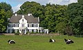 Country house De Tangh


References
- "Kerncijfers wijken en buurten 2021". Central Bureau of Statistics. Retrieved 27 March 2022.
three entries
- "Postcodetool for 3921AA". Actueel Hoogtebestand Nederland (in Dutch). Het Waterschapshuis. Retrieved 27 March 2022.
- Ronald Stenvert & Chris Kolman (1996). "Elst" (in Dutch). Zwolle: Waanders. ISBN 90 400 9757 7. Retrieved 26 March 2022.
- "Elst (Utrecht)". Plaatsengids (in Dutch). Retrieved 27 March 2022.
- "Elst - (geografische naam)". Etymologiebank (in Dutch). Retrieved 27 March 2022.
- "'t Wissel". Molen database (in Dutch). Retrieved 27 March 2022.
| Wikimedia Commons has media related to Elst, Utrecht. |
This Utrecht location article is a stub. You can help Wikipedia by expanding it. |
Другой контент может иметь иную лицензию. Перед использованием материалов сайта WikiSort.org внимательно изучите правила лицензирования конкретных элементов наполнения сайта.
WikiSort.org - проект по пересортировке и дополнению контента Википедии