world.wikisort.org - Netherlands
Den Hout is a village in the Dutch province of North Brabant. It is located in the municipality of Oosterhout.[3][4]
Den Hout | |
|---|---|
Village | |
 Inn 't Klosterke | |
 Den Hout Location in the province of North Brabant in the Netherlands  Den Hout Den Hout (Netherlands) | |
| Coordinates: 51°39′28″N 4°48′42″E | |
| Country | Netherlands |
| Province | North Brabant |
| Municipality | Oosterhout |
| Area | |
| • Total | 7.91 km2 (3.05 sq mi) |
| Elevation | 2.3 m (7.5 ft) |
| Population (2021)[1] | |
| • Total | 1,235 |
| • Density | 160/km2 (400/sq mi) |
| Time zone | UTC+1 (CET) |
| • Summer (DST) | UTC+2 (CEST) |
| Postal code | 4911[1] |
| Dialing code | 0162 |
The village was first mentioned in 1311 as "Rolinus dictus van den Houte", and means deciduous forest.[5] The area around Den Hout was settled during Roman times, but abandoned in 273.[4] Den Hout developed in the Middle Ages around a triangular village square.[6]
The St Cornelius Church was built between 1877 and 1878 in Gothic Revival style and as an octagon spire.[6]
Den Hout was home to 650 people in 1840.[4]
Gallery
 Pavillion Het Houtse Meer
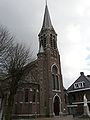 St Cornelius Church
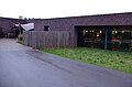
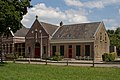 Association building
 School in Den Hout


References
- "Kerncijfers wijken en buurten 2021". Central Bureau of Statistics. Retrieved 18 April 2022.
- "Postcodetool for 4911AA". Actueel Hoogtebestand Nederland (in Dutch). Het Waterschapshuis. Retrieved 18 April 2022.
- "Den Hout". www.denhout.eu. Retrieved Jan 10, 2020.
- "Den Hout". Plaatsengids (in Dutch). Retrieved 18 April 2022.
- "Den Hout - (geografische naam)". Etymologiebank (in Dutch). Retrieved 18 April 2022.
- Chris Kolman & Ronald Stenvert (1997). Den Hout (in Dutch). Zwolle: Waanders. ISBN 90 400 9945 6. Retrieved 18 April 2022.
Wikimedia Commons has media related to Den Hout.
This North Brabant location article is a stub. You can help Wikipedia by expanding it. |
Текст в блоке "Читать" взят с сайта "Википедия" и доступен по лицензии Creative Commons Attribution-ShareAlike; в отдельных случаях могут действовать дополнительные условия.
Другой контент может иметь иную лицензию. Перед использованием материалов сайта WikiSort.org внимательно изучите правила лицензирования конкретных элементов наполнения сайта.
Другой контент может иметь иную лицензию. Перед использованием материалов сайта WikiSort.org внимательно изучите правила лицензирования конкретных элементов наполнения сайта.
2019-2026
WikiSort.org - проект по пересортировке и дополнению контента Википедии
WikiSort.org - проект по пересортировке и дополнению контента Википедии