world.wikisort.org - Netherlands
Dalem is a village in the Dutch province of South Holland. It is located in the municipality of Gorinchem, about 2 km east of the city.
Dalem | |
|---|---|
Village | |
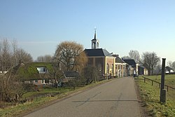
 View on Dalem | |
 Dalem Location in the province of South Holland in the Netherlands  Dalem Location in the Netherlands | |
| Coordinates: 51°49′40″N 05°00′34″E | |
| Country | Netherlands |
| Province | South Holland |
| Municipality | Gorinchem |
| Area | |
| • Total | 1.50 km2 (0.58 sq mi) |
| Elevation | 0.3 m (1.0 ft) |
| Population (2021)[1] | |
| • Total | 885 |
| • Density | 590/km2 (1,500/sq mi) |
| Time zone | UTC+1 (CET) |
| • Summer (DST) | UTC+2 (CEST) |
| Postal code | 4213[1] |
| Dialing code | 0183 |
It was first mentioned in 1343 as Dalem, and means "low-lying settlement". It should not be confused with the nearby hamlet Laag-Dalem which has become a neighbourhood of Gorinchem.[3][4] Dalem is a dike village which probably developed around the 11th century along the Boven-Merwede. The Dutch Reformed church is an aisleless church with a doomed roof. An obelisk has been placed on top of the roof. In 2001, it was discovered that the roof had become unstable, and the local congregation could not afford a restoration. In 2004, it was sold to the municipality and restored.[4]
Dalem was a separate municipality until 1818, when it was renamed to "Vuren", the name of the other village in the municipality. The village was part of the province of Gelderland until 1986, when the municipality of Vuren ceased to exist, and Dalem became part of Gorinchem,[5] thereby becoming part of the province of South Holland.[4]
Gallery
- Postcard of Dalem
- Dutch Reformed church
References
- "Kerncijfers wijken en buurten 2021". Central Bureau of Statistics. Retrieved 3 May 2022.
- "Postcodetool for 4213CD". Actueel Hoogtebestand Nederland (in Dutch). Het Waterschapshuis. Retrieved 3 May 2022.
- "Dalem - (geografische naam)". Etymologiebank (in Dutch). Retrieved 3 May 2022.
- "Dalem". Plaatsengids (in Dutch). Retrieved 3 May 2022.
- Ad van der Meer and Onno Boonstra, "Repertorium van Nederlandse gemeenten", KNAW, 2006. "KNAW > Publicaties > Detailpagina". Archived from the original on 2007-02-20. Retrieved 2009-12-03.
Другой контент может иметь иную лицензию. Перед использованием материалов сайта WikiSort.org внимательно изучите правила лицензирования конкретных элементов наполнения сайта.
WikiSort.org - проект по пересортировке и дополнению контента Википедии

