world.wikisort.org - Netherlands
Benschop is a village in the Dutch province of Utrecht. It is a part of the municipality of Lopik, and lies about 4 km west of IJsselstein. Benschop is an extremely long village: apart from a relatively compact town centre, it consists of a long ribbon (over 8 km long) of houses (mainly farms) on both sides of the Benschopsche Wetering. Until 1989, Benschop was a separate municipality.
Benschop | |
|---|---|
Village | |
 De Nicolaaskerk van Benschop | |
 Benschop Location in the Netherlands  Benschop Benschop (Netherlands) | |
| Coordinates: 52°0′26″N 4°58′46″E | |
| Country | Netherlands |
| Province | Utrecht |
| Municipality | Lopik |
| Area | |
| • Total | 22.97 km2 (8.87 sq mi) |
| Elevation | −0.4 m (−1.3 ft) |
| Population (2021)[1] | |
| • Total | 3,575 |
| • Density | 160/km2 (400/sq mi) |
| Time zone | UTC+1 (CET) |
| • Summer (DST) | UTC+2 (CEST) |
| Postal code | 3405[1] |
| Dialing code | 0348 |
History
The village was first mentioned between 1280 and 1287 as benscop, and means "(peat) concession of Ben (person)".[3] Excavation of the peat started in the 11th and 12th century.[4] Benschop used to be part of the Prince-Bishopric of Utrecht. In 1285, the village became part of Holland.[5]
The Dutch Reformed Church dates from around 1500, but has 13th century elements. Huis Snellenburg was a manor house built around 1700. It was redeveloped into a farm, however the interior and the carriage house remain.[4] In 1805, Benschop was returned to Utrecht. In 1840, it was home to 1,415 people. Benschop used to be an independent municipality. In 1989, it was merged into Lopik.[5]
Gallery
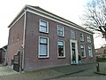 House in Benschop
 Farm in Benschop
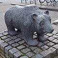 The bear of Benschop by Inez van Dijk
 Huis Snellenburg (1839)


References
- "Kerncijfers wijken en buurten 2021". Central Bureau of Statistics. Retrieved 28 March 2022.
two entries
- "Postcodetool for 3405AA". Actueel Hoogtebestand Nederland (in Dutch). Het Waterschapshuis. Retrieved 28 March 2022.
- "Benschop - (geografische naam)". Etymologiebank (in Dutch). Retrieved 28 March 2022.
- Ronald Stenvert & Chris Kolman (1996). "Benschop" (in Dutch). Zwolle: Waanders. ISBN 90 400 9757 7. Retrieved 28 March 2022.
- "Benschop". Plaatsengids (in Dutch). Retrieved 28 March 2022.
Другой контент может иметь иную лицензию. Перед использованием материалов сайта WikiSort.org внимательно изучите правила лицензирования конкретных элементов наполнения сайта.
WikiSort.org - проект по пересортировке и дополнению контента Википедии